Old Maps of Mentasta Lake, Alaska for Academic Research
Study the evolution of Mentasta Lake with 7 high-resolution historic maps. Whether you're teaching, researching, or modeling changes in land use, these maps provide essential visual documentation of urban, environmental, and geographic change.
- Analyze long-term change: Track patterns in development, transportation, and natural features.
- Ideal for environmental or urban studies: Support academic projects with primary historical map data.
- Use in the classroom or lab: Educators and researchers rely on these maps to bring historical context to life.
These maps are a powerful tool for teaching, research, and visualizing how Mentasta Lake has changed over the decades.
Mentasta Lake, AK maps
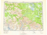
(7)- 1949 Map of Nabesna D-6, 1964 Print
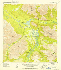
 1949 Nabesna D-61964 Print · USGSThe Slana River valley and Mentasta Mountains appear here in the years following World War II, showing a landscape defined by traditional trails and new highways. Trace early interior travel via the Eagle Trail, Mentasta Pass, and the remote Lodge on the highway.5 unique versions available
 - 1950 Map of Nabesna, 1954 Print
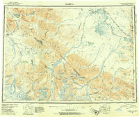 1950 Nabesna1954 Print · USGSInterior Alaska in the early fifties shows a rugged transition from mountain glaciers to river-basin settlements before statehood. Researchers can trace the remote mining outposts of Nabesna and Chisana or locate old airstrips like Reeve Field and Northway Landing Field.4 unique versions available
 - 1951 Map of Nabesna
 1951 Nabesna1951 Print · USGSThe Alaska interior comes into focus during the early fifties, showing the vast Tetlin Indian Reservation and the rise of bush pilot culture. You can trace the routes of the Alaska Highway and find remote camps like Indian Pass Inn or Chisana.3 unique versions available
 - 1952 Map of Nabesna D-6
 1952 Nabesna D-61952 Print · USGSThe northern Mentasta Mountains are documented here in the early fifties during a period of significant road construction. Researchers can locate the settlement of Mentasta Lake, the Bear Cub Inn, and trace the path of the Eagle Trail through Indian Pass.2 unique versions available
 - 1960 Map of Nabesna, 1966 Print
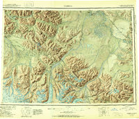
 1960 Nabesna1966 Print · USGSEastern Alaska's interior at the dawn of the sixties shows a landscape of remote indigenous villages and highway outposts. Genealogists and historians can locate Northway Indian Village, the Seaton Roadhouse, and mining history at Nabesna.5 unique versions available
 - 2016 Map of Nabesna D-6 NW, 2016 Print
 2016 Nabesna D-6 NW2016 Print · USGSCovers Mentasta Lake, including Unorganized Borough, United States, and other nearby areas
 - 2023 Map of Nabesna D-6 NW, 2023 Print
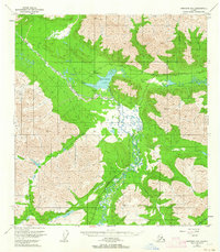
 2023 Nabesna D-6 NW2023 Print · USGSThe Slana River valley and the waters of Mentasta Lake are captured here in the early twenty-first century. Modern researchers can trace the intersection of the Slana River Trl with Mentasta Spur Road through this interior Alaskan wilderness.
End of results
Showing maps 1-7 of 7
Frequently asked questions
- What are the different types of historical maps available for Mentasta Lake?
- What is the oldest map of Mentasta Lake?
- Where can I purchase historical maps of Mentasta Lake for my home or office?
- Where can I download high-res historical maps of Mentasta Lake?
- Are there historical topographic maps available for Mentasta Lake?
- Is there historical aerial imagery available for Mentasta Lake?
- Where are historical maps of Mentasta Lake sourced from?