Old Maps of Mountain Village, Alaska for Academic Research
Study the evolution of Mountain Village with 4 high-resolution historic maps. Whether you're teaching, researching, or modeling changes in land use, these maps provide essential visual documentation of urban, environmental, and geographic change.
- Analyze long-term change: Track patterns in development, transportation, and natural features.
- Ideal for environmental or urban studies: Support academic projects with primary historical map data.
- Use in the classroom or lab: Educators and researchers rely on these maps to bring historical context to life.
These maps are a powerful tool for teaching, research, and visualizing how Mountain Village has changed over the decades.
Mountain Village, AK maps
(4)- 1952 Map of Kwiguk
 1952 Kwiguk1952 Print · USGSThe Yukon Delta in the early fifties was a vast network of seasonal waterways and remote outposts. Researchers can trace the Winter Trail past Bill Moores or locate historic river settlements like New Fort Hamilton and Akulurak P O.8 unique versions available
 - 1952 Map of Kwiguk A-4, 1959 Print
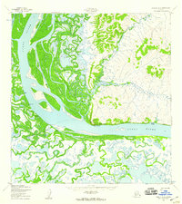 1952 Kwiguk A-41959 Print · USGSThe lower Yukon River corridor is captured here in the early fifties, documenting a landscape shaped by seasonal trails and riparian settlements. Researchers can trace the layout of Mountain Village or locate local sites like Kazhutak and Johnnys Village.3 unique versions available
 - 2020 Map of Kwiguk A-4 SW, 2020 Print
 2020 Kwiguk A-4 SW2020 Print · USGSThe lower Yukon Delta remains a wild expanse of braided channels and seasonal wetlands in this recent survey. Researchers can trace the winding course of the Archuelinguk River and find the location of Spring Water Road along the main riverbank.
 - 2020 Map of Kwiguk A-4 SE, 2020 Print
 2020 Kwiguk A-4 SE2020 Print · USGSThe northern banks of the Yukon River in the early twenty-first century reveal the established layout of Mountain Village. Genealogists and researchers can trace local infrastructure from the Mountain Village Airport to streets like B Street and Spring Water Road.
End of results
Showing maps 1-4 of 4
Frequently asked questions
- What are the different types of historical maps available for Mountain Village?
- What is the oldest map of Mountain Village?
- Where can I purchase historical maps of Mountain Village for my home or office?
- Where can I download high-res historical maps of Mountain Village?
- Are there historical topographic maps available for Mountain Village?
- Is there historical aerial imagery available for Mountain Village?
- Where are historical maps of Mountain Village sourced from?