Old Maps of Nash Harbor, Alaska for Genealogy
Trace your family roots with 6 historic maps of Nash Harbor. These high-res maps reveal old neighborhoods, homesites, landmarks, and streets — helping you uncover where your ancestors lived and how the area evolved over time.
- Explore historic neighborhoods: Identify where your relatives may have lived in the 1800s or 1900s.
- Compare maps over time: Trace the changes in streets, buildings, and landmarks for multi-generational research.
- Perfect for genealogy & ancestry research: Used by family historians and researchers to map out lineage and migration.
These maps are an incredible resource for exploring your personal connection to Nash Harbor's past.
Nash Harbor, AK maps
(6)- 1951 Map of Nunivak Island
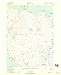
 1951 Nunivak Island1951 Print · USGSNunivak Island and the eastern Bering Sea coast appear here in the early fifties, showing a remote landscape of subsistence settlements and wildlife refuge lands. Researchers can trace historic sites like Mekoryuk, Kigoumiut, and the Nash Harbor Landing Area.
 - 1952 Map of Nunivak Island A-6, 1958 Print
 1952 Nunivak Island A-61958 Print · USGSNunivak Island in the early fifties shows a landscape defined by traditional seasonal patterns and coastal navigation. Researchers can trace indigenous summer sites like Kigoumiut, find isolated cabins at Nash Harbor, and locate landmarks such as Seemalik Butte.3 unique versions available
 - 1954 Map of Nunivak Island, 1961 Print
 1954 Nunivak Island1961 Print · USGSNunivak Island and the adjacent Etolin Strait are documented in the mid-1950s, showing a traditional landscape of coastal camps and settlements. Researchers can locate established sites like Mekoryuk and Tanunak or trace seasonal camps at Nash Harbor and Kuvloniut.4 unique versions available
 - 1958 Map of Nunivak Island
 1958 Nunivak Island1958 Print · USGSNunivak Island and Nelson Island appear in the mid-1950s as a series of remote coastal outposts and wildlife habitats. Researchers can locate seasonal camps and landing sites like Nash Harbor, the settlement of Mekoryuk, and landmarks like Cape Mohican.
 - 1964 Map of Nunivak Island
 1964 Nunivak Island1964 Print · USGSNunivak Island and the Bering Sea coast appear here during the mid-1960s, documenting a landscape of traditional Indigenous settlements and federal wildlife refuges. Researchers can locate seasonal camp sites like Luktukukwik and major landmarks including Mekoryuk and the Cape Mohican Light.
 - 2020 Map of Nunivak Island A-6 NE, 2020 Print
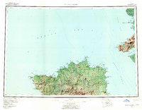
 2020 Nunivak Island A-6 NE2020 Print · USGSNunivak Island's northern shores are documented here in the early twenty-first century, showing the relationship between the sea and its coastal bluffs. Researchers can trace landforms like Binakslit Bluff and Nash Harbor or locate interior features like Unroojitok Lake.
End of results
Showing maps 1-6 of 6
Frequently asked questions
- What are the different types of historical maps available for Nash Harbor?
- What is the oldest map of Nash Harbor?
- Where can I purchase historical maps of Nash Harbor for my home or office?
- Where can I download high-res historical maps of Nash Harbor?
- Are there historical topographic maps available for Nash Harbor?
- Is there historical aerial imagery available for Nash Harbor?
- Where are historical maps of Nash Harbor sourced from?