1900s (20th Century) Maps of Nightmute, Alaska
Explore 11 historic maps of Nightmute from the 1900s (20th Century). These maps offer a rare glimpse into what life looked like during the 1900s — showing old roads, neighborhoods, homes, and landmarks that have changed or disappeared over time.
Whether you're researching your family's past, planning a metal detecting trip, or studying how Nightmute's landscape evolved across the 1900s, these high-resolution maps are a powerful tool for exploring the history of this region.
- Focus on a specific era: All maps on this page are from the 1900s, giving you a focused view of this time period.
- See what’s changed: Compare century-old streets, trails, and buildings to today's modern landscape using overlays and satellite layers.
- Research with precision: Use these maps for genealogy, historical research, land use analysis, or educational projects.
- View, download, or print: Maps are fully viewable online in high resolution, and can be downloaded or printed for your own records.
Start exploring Nightmute's history through authentic maps from the 1900s. This is your window into the past.
Nightmute, AK maps
(11)- 1951 Map of Nunivak Island
 1951 Nunivak Island1951 Print · USGSNunivak Island and the eastern Bering Sea coast appear here in the early fifties, showing a remote landscape of subsistence settlements and wildlife refuge lands. Researchers can trace historic sites like Mekoryuk, Kigoumiut, and the Nash Harbor Landing Area.
 - 1951 Map of Baird Inlet, 1953 Print
 1951 Baird Inlet1953 Print · USGSThe Yukon-Kuskokwim Delta's vast water-webbed landscape is shown here in the early fifties during a period of transition. Genealogists and researchers can trace the locations of traditional sites like Nunapitchuk alongside several sites marked as abandoned, such as Akulurak and Kinak.
 - 1954 Map of Nunivak Island, 1961 Print
 1954 Nunivak Island1961 Print · USGSNunivak Island and the adjacent Etolin Strait are documented in the mid-1950s, showing a traditional landscape of coastal camps and settlements. Researchers can locate established sites like Mekoryuk and Tanunak or trace seasonal camps at Nash Harbor and Kuvloniut.4 unique versions available
 - 1954 Map of Baird Inlet, 1967 Print
 1954 Baird Inlet1967 Print · USGSThe Yukon-Kuskokwim Delta comes into focus in the mid-1950s, showing a vast network of tundra lakes and coastal estuaries. Researchers can locate active villages like Chefornak and Kasigluk or trace historical settlement sites such as Chakchak and Monrak.3 unique versions available
 - 1954 Map of Baird Inlet B-7, 1971 Print
 1954 Baird Inlet B-71971 Print · USGSThe Yukon-Kuskokwim Delta's complex water network is frozen in time during the mid-fifties, showing the region before modern changes. Researchers can locate seasonal habitation points at Monrak (Site) and trace the tidal Kolavinarak River.
 - 1954 Map of Baird Inlet C-8, 1971 Print
 1954 Baird Inlet C-81971 Print · USGSNelson Island and the Bering Sea coast are captured in detail during the mid-fifties as the Army Map Service documented this maritime landscape. Researchers can trace the winding Toksook River and locate coastal landmarks like Erchakrtuk Mountain and Hazen Bay.
 - 1954 Map of Nunivak Island B-1, 1971 Print
 1954 Nunivak Island B-11971 Print · USGSNelson Island and the surrounding Bering Sea waters are captured here in the mid-fifties, showing the coastal geography of western Alaska. Researchers can locate the settlement of Umkumiut and trace the shoreline between Chinigyak Cape and Atrnak Point.
 - 1954 Map of Baird Inlet B-8, 1971 Print
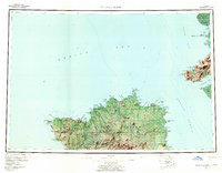
 1954 Baird Inlet B-81971 Print · USGSNelson Island and the surrounding tundra are captured here in the mid-fifties, showing a landscape of seasonal camps and coastal waterways. Researchers can trace ancestral locations like Nightmute, the Kanloyak (Site), and the Knugormiut Summer Camp.
 - 1954 Map of Nunivak Island C-1, 1971 Print
 1954 Nunivak Island C-11971 Print · USGSNelson Island is documented here in the mid-fifties, showing the coastal villages and high peaks of the Bering Sea coast. Researchers can trace early settlements and infrastructure at Tanunak, the Toksook Bay area, and the Nililugruk camp.
 - 1958 Map of Nunivak Island
 1958 Nunivak Island1958 Print · USGSNunivak Island and Nelson Island appear in the mid-1950s as a series of remote coastal outposts and wildlife habitats. Researchers can locate seasonal camps and landing sites like Nash Harbor, the settlement of Mekoryuk, and landmarks like Cape Mohican.
 - 1964 Map of Nunivak Island
 1964 Nunivak Island1964 Print · USGSNunivak Island and the Bering Sea coast appear here during the mid-1960s, documenting a landscape of traditional Indigenous settlements and federal wildlife refuges. Researchers can locate seasonal camp sites like Luktukukwik and major landmarks including Mekoryuk and the Cape Mohican Light.
End of results
Showing maps 1-11 of 11
Top cities near Nightmute
Frequently asked questions
- What are the different types of historical maps available for Nightmute?
- What is the oldest map of Nightmute?
- Where can I purchase historical maps of Nightmute for my home or office?
- Where can I download high-res historical maps of Nightmute?
- Are there historical topographic maps available for Nightmute?
- Is there historical aerial imagery available for Nightmute?
- Where are historical maps of Nightmute sourced from?