Old Maps of Ophir, Alaska for Hiking & Exploration
Hike through history with 4 historic maps of Ophir. Explore old trails, ghost towns, and forgotten backroads — perfect for outdoor adventurers and local explorers.
- Rediscover forgotten places: Map out old mining camps, roads, and footpaths that no longer exist on modern maps.
- Layer with modern tools: Combine with LiDAR or satellite views to plan hikes through historical terrain.
- Made for exploration: Popular among hikers, overlanders, and local history lovers.
Use these maps to find adventure and explore the hidden past of Ophir.
Ophir, AK maps
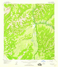
(4)- 1951 Map of Ophir
 1951 Ophir1951 Print · USGSThe Innoko River valley in the early fifties shows a landscape defined by gold mining and seasonal wilderness travel. Trace old routes like the Winter Trail and locate remote outposts such as Dishkakat (Aban'd) and Ophir.
 - 1954 Map of Ophir A-2, 1958 Print
 1954 Ophir A-21958 Print · USGSThe mining outpost of Ophir and its surroundings are captured here during the mid-1950s, showing a landscape defined by gold prospecting. Researchers can trace early aviation and mining infrastructure, from the Airstrip to remote sites like the Placer Mine and Gold Run.3 unique versions available
 - 1954 Map of Ophir, 1965 Print
 1954 Ophir1965 Print · USGSThe interior Alaska wilderness near the confluence of the Innoko and Dishna Rivers is documented here during the mid-fifties. Researchers can locate several legacy settlements including Dishkakat and Ophir, alongside a Placer Mine and the Winter Trail.3 unique versions available
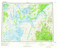
 - 2019 Map of Ophir A-2 NE, 2019 Print
 2019 Ophir A-2 NE2019 Print · USGSThe historic mining district of Ophir is captured here in the late 2010s, situated deep within the Yukon-Koyukuk interior. Researchers can trace the Sterling Landing-Takotna-Ophir Road to Ophir and the banks of the Innoko River.
End of results
Showing maps 1-4 of 4
Frequently asked questions
- What are the different types of historical maps available for Ophir?
- What is the oldest map of Ophir?
- Where can I purchase historical maps of Ophir for my home or office?
- Where can I download high-res historical maps of Ophir?
- Are there historical topographic maps available for Ophir?
- Is there historical aerial imagery available for Ophir?
- Where are historical maps of Ophir sourced from?