Old Maps of Pikmiktalik, Alaska for Metal Detecting
Plan your next treasure hunt with 5 historic maps of Pikmiktalik. Find old homesites, ghost towns, trails, and gathering spots that may be lost to time — perfect for identifying promising metal detecting locations.
- Locate forgotten sites: Uncover places like long-lost settlements, abandoned rail lines, or gathering spots.
- Plan better hunts: Use map overlays combined with LiDAR or satellite views to narrow in on historically rich areas.
- Made for detectorists: Thousands of hobbyists use these maps to discover relics, coins, and hidden history.
Use these historic maps to boost your research and find new opportunities beneath the surface of Pikmiktalik.
Pikmiktalik, AK maps
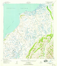
(5)- 1951 Map of St Michael
 1951 St Michael1951 Print · USGSCoastal Alaska at the mid-century reveals a world of remote outposts and intricate delta waterways. Researchers can trace the riverine geography of Kotlik, the settlement at St Michael, and traditional sites like Pastolik or Chaniliut along Norton Sound.
 - 1952 Map of Saint Michael A-2, 1958 Print
 1952 Saint Michael A-21958 Print · USGSThe coastal frontier of western Alaska is recorded here in the early fifties, documenting the remote reaches of Pastol Bay and Norton Sound. Trace the location of Nokrot (Aband), the maritime beacon at Romanof Light, and the routes of an approximate Winter Trail.2 unique versions available
 - 1952 Map of St Michael, 1959 Print
 1952 St Michael1959 Print · USGSThe northern Yukon-Kuskokwim Delta meets the sea in the early fifties, documenting a landscape of coastal villages and complex river passes. Researchers can trace the ancestral locations of Kotlik, Stebbins, and Nokogamiut alongside the historic ST MICHAEL TRAIL.4 unique versions available
 - 1964 Map of St. Michael
 1964 St. Michael1964 Print · USGSCoastal settlements and the vast Yukon Delta waterways are charted here during the mid-1960s. Genealogists and historians can trace the locations of traditional villages like Kotlik, Nunaktuk, and Chaniliut along the Apoon Mouth.
 - 2017 Map of Saint Michael A-2 NE, 2017 Print
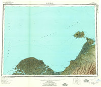
 2017 Saint Michael A-2 NE2017 Print · USGSThe coastal wetlands along Norton Sound are captured here in the years following the turn of the millennium. Researchers can trace the winding course of the Pikmiktalik River and locate the settlement of Pikmiktalik near the shoreline of the Pacific Ocean.
End of results
Showing maps 1-5 of 5
Top cities near Pikmiktalik
Frequently asked questions
- What are the different types of historical maps available for Pikmiktalik?
- What is the oldest map of Pikmiktalik?
- Where can I purchase historical maps of Pikmiktalik for my home or office?
- Where can I download high-res historical maps of Pikmiktalik?
- Are there historical topographic maps available for Pikmiktalik?
- Is there historical aerial imagery available for Pikmiktalik?
- Where are historical maps of Pikmiktalik sourced from?