Old Maps of Ptarmigan, Alaska for Metal Detecting
Plan your next treasure hunt with 5 historic maps of Ptarmigan. Find old homesites, ghost towns, trails, and gathering spots that may be lost to time — perfect for identifying promising metal detecting locations.
- Locate forgotten sites: Uncover places like long-lost settlements, abandoned rail lines, or gathering spots.
- Plan better hunts: Use map overlays combined with LiDAR or satellite views to narrow in on historically rich areas.
- Made for detectorists: Thousands of hobbyists use these maps to discover relics, coins, and hidden history.
Use these historic maps to boost your research and find new opportunities beneath the surface of Ptarmigan.
Ptarmigan, AK maps
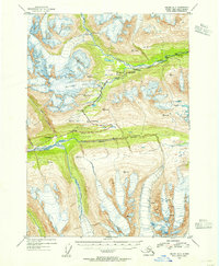
(5)- 1952 Map of Valdez
 1952 Valdez1952 Print · USGSCoastal Alaska met the interior via mountain passes and river valleys during the mid-century, before the 1964 earthquake altered the shoreline. Trace mining history at Midas Camp and Cliff Mine, or locate remote stations like Tiekel Cache and Copper Center.4 unique versions available
 - 1953 Map of Valdez A-5, 1955 Print
 1953 Valdez A-51955 Print · USGSAlaska's interior transit corridor is captured here in the early fifties, following the Richardson Highway through the high peaks. Local historians can trace early roadside stops at Wortmanns, the ARC Camp, and the icy expanse of the Worthington Glacier.6 unique versions available
 - 1960 Map of Valdez, 1967 Print
 1960 Valdez1967 Print · USGSCoastal and interior Alaska meet in this mid-century study of the Chugach Mountains and the copper-rich river valleys. Trace the legacy of early industry along the Copper River and Northwestern Railroad and locate settlements like Copper Center, Chitina, and Fort Liscum.6 unique versions available
 - 2016 Map of Valdez A-5 NE, 2016 Print
 2016 Valdez A-5 NE2016 Print · USGSCovers Ptarmigan, including Unorganized Borough, United States, and other nearby areas
 - 2023 Map of Valdez A-5 NE, 2023 Print
 2023 Valdez A-5 NE2023 Print · USGSThe Richardson Highway corridor comes alive in this 2023 survey of the Chugach Mountains. Researchers can trace the path of the Alaska Pipeline past the Thompson Pass Airport and the small settlement of Ptarmigan.
End of results
Showing maps 1-5 of 5
Top cities near Ptarmigan
Frequently asked questions
- What are the different types of historical maps available for Ptarmigan?
- What is the oldest map of Ptarmigan?
- Where can I purchase historical maps of Ptarmigan for my home or office?
- Where can I download high-res historical maps of Ptarmigan?
- Are there historical topographic maps available for Ptarmigan?
- Is there historical aerial imagery available for Ptarmigan?
- Where are historical maps of Ptarmigan sourced from?