Old Maps of Savoonga, Alaska
Explore 5 old maps of Savoonga, spanning from 1948 to today. These high-resolution historic maps reveal how streets, neighborhoods, landmarks, and natural features evolved over time — perfect for genealogy, metal detecting, research, and local history exploration.
What you can do with these maps:
- See how Savoonga changed over time: Compare historical maps to modern-day views to trace roads, homesites, rail lines & more.
- View detailed metadata: Each map includes creators, publishers, year, scale, and archive source.
- Overlay maps with satellite & LiDAR: Visualize the past alongside modern tools to explore terrain & human change.
- Trusted historical sources: Maps sourced from the USGS, Library of Congress, and other archives.
- Access maps your way: View online, download high-res files, or order prints for personal or research use.
Start exploring old maps of Savoonga to uncover forgotten places, hidden landmarks, and the deep history beneath your feet.
Savoonga, AK maps
(5)- 1948 Map of St Lawrence, 1954 Print
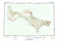 1948 St Lawrence1954 Print · USGSSaint Lawrence Island in the late 1940s is shown as a land of seasonal movement and subsistence living. Researchers can trace historic sites like the Kukuliak (Old Village Site), locate Ataaka's Camp, and follow the established Winter Trail across the island.7 unique versions available
 - 1949 Map of St Lawrence
 1949 St Lawrence1949 Print · USGSSt. Lawrence Island in the Bering Sea is shown here as it transitioned into the mid-twentieth century, dominated by subsistence camps and traditional trails. Researchers can trace seasonal sites like Ataaka's Camp, the Reindeer Camp and Corral, and the Kukuliak (Old Village Site).2 unique versions available
 - 1964 Map of St Lawrence
 1964 St Lawrence1964 Print · USGSSt. Lawrence Island appears in the mid-sixties as a landscape of subsistence camps and ancient village sites in the Bering Sea. Researchers can locate traditional outposts like Siknik Trapping Camp, the Kookoolik (Old Village Site), and Reindeer Camp.
 - 2020 Map of Saint Lawrence D-3 SW, 2020 Print
 2020 Saint Lawrence D-3 SW2020 Print · USGSSavoonga sits on the northern edge of Saint Lawrence Island in the Bering Sea during the early twenty-first century. Researchers can trace the layout of the settlement and its coastal surroundings, from Savoonga Airport to landmarks like Kookoolik Hill and Puk-luk Bay.
 - 2020 Map of Saint Lawrence D-4 SE, 2020 Print
 2020 Saint Lawrence D-4 SE2020 Print · USGSSavoonga sits at the edge of the Bering Sea in the twenty-first century, serving as a vital northern outpost on the island's coast. Researchers can trace local infrastructure and coastal geography through the Savoonga Airport, Kinney Road, and Lyeelghit Cliff.
End of results
Showing maps 1-5 of 5
Frequently asked questions
- What are the different types of historical maps available for Savoonga?
- What is the oldest map of Savoonga?
- Where can I purchase historical maps of Savoonga for my home or office?
- Where can I download high-res historical maps of Savoonga?
- Are there historical topographic maps available for Savoonga?
- Is there historical aerial imagery available for Savoonga?
- Where are historical maps of Savoonga sourced from?