Old Maps of Stebbins, Alaska for Genealogy
Trace your family roots with 9 historic maps of Stebbins. These high-res maps reveal old neighborhoods, homesites, landmarks, and streets — helping you uncover where your ancestors lived and how the area evolved over time.
- Explore historic neighborhoods: Identify where your relatives may have lived in the 1800s or 1900s.
- Compare maps over time: Trace the changes in streets, buildings, and landmarks for multi-generational research.
- Perfect for genealogy & ancestry research: Used by family historians and researchers to map out lineage and migration.
These maps are an incredible resource for exploring your personal connection to Stebbins's past.
Stebbins, AK maps
(9)- 1951 Map of St Michael
 1951 St Michael1951 Print · USGSCoastal Alaska at the mid-century reveals a world of remote outposts and intricate delta waterways. Researchers can trace the riverine geography of Kotlik, the settlement at St Michael, and traditional sites like Pastolik or Chaniliut along Norton Sound.
 - 1952 Map of Saint Michael C-1, 1958 Print
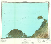
 1952 Saint Michael C-11958 Print · USGSThe remote coast of Norton Sound is captured here in the early fifties, showing the relationship between island settlements and the sea. Trace the old Trail near Stebbins or locate the Light at Cape Stephens and the seasonal Cabins.2 unique versions available
 - 1952 Map of Saint Michael B-1, 1958 Print
 1952 Saint Michael B-11958 Print · USGSSaint Michael was a vital Bering Sea port and administrative center in the early 1950s, captured here amidst a vast network of coastal canals and tundra. Researchers can trace the layout of the Saint Michael settlement, the U. S. School Reserve, and the historic Russian Gardens.2 unique versions available
 - 1952 Map of St Michael, 1959 Print
 1952 St Michael1959 Print · USGSThe northern Yukon-Kuskokwim Delta meets the sea in the early fifties, documenting a landscape of coastal villages and complex river passes. Researchers can trace the ancestral locations of Kotlik, Stebbins, and Nokogamiut alongside the historic ST MICHAEL TRAIL.4 unique versions available
 - 1964 Map of St. Michael
 1964 St. Michael1964 Print · USGSCoastal settlements and the vast Yukon Delta waterways are charted here during the mid-1960s. Genealogists and historians can trace the locations of traditional villages like Kotlik, Nunaktuk, and Chaniliut along the Apoon Mouth.
 - 2017 Map of Saint Michael C-1 SW, 2017 Print
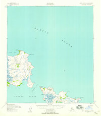
 2017 Saint Michael C-1 SW2017 Print · USGSStebbins and the surrounding coastal landscape of Stuart Island are captured in this 2017 survey. Researchers can trace the layout of Stebbins and identify local landmarks like the Stebbins Cem, Stebbins Airport, and the prominent Stuart Mtn.
 - 2017 Map of Saint Michael C-1 SE, 2017 Print
 2017 Saint Michael C-1 SE2017 Print · USGSCoastal communities in the Nome Census Area are documented here in the early twenty-first century. Researchers can trace the path of the Stebbins - Saint Michael Road between Stebbins and St. Michael, or locate landmarks like Stephens Hill.
 - 2017 Map of Saint Michael B-1 NE, 2017 Print
 2017 Saint Michael B-1 NE2017 Print · USGSThe coastal settlement of Saint Michael is captured here during the late twenty-teens, showing the unique intersection of the Norton Sound and the Alaskan tundra. Researchers can trace the local road network and identify landmarks like Saint Michael Mtn and the St. Michael Airport.
 - 2017 Map of Saint Michael B-1 NW, 2017 Print
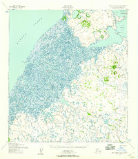
 2017 Saint Michael B-1 NW2017 Print · USGSThe coastal village of Stebbins and the marshy reaches of the Nome Census Area appear in high detail during the late twenty-teens. Researchers can trace the winding paths of the Saint Michael Canal and Nunavulnuk River across this complex aquatic landscape.
End of results
Showing maps 1-9 of 9
Frequently asked questions
- What are the different types of historical maps available for Stebbins?
- What is the oldest map of Stebbins?
- Where can I purchase historical maps of Stebbins for my home or office?
- Where can I download high-res historical maps of Stebbins?
- Are there historical topographic maps available for Stebbins?
- Is there historical aerial imagery available for Stebbins?
- Where are historical maps of Stebbins sourced from?