Old Maps of Toklat, Alaska
Explore 7 old maps of Toklat, spanning from 1948 to today. These high-resolution historic maps reveal how streets, neighborhoods, landmarks, and natural features evolved over time — perfect for genealogy, metal detecting, research, and local history exploration.
What you can do with these maps:
- See how Toklat changed over time: Compare historical maps to modern-day views to trace roads, homesites, rail lines & more.
- View detailed metadata: Each map includes creators, publishers, year, scale, and archive source.
- Overlay maps with satellite & LiDAR: Visualize the past alongside modern tools to explore terrain & human change.
- Trusted historical sources: Maps sourced from the USGS, Library of Congress, and other archives.
- Access maps your way: View online, download high-res files, or order prints for personal or research use.
Start exploring old maps of Toklat to uncover forgotten places, hidden landmarks, and the deep history beneath your feet.
Toklat, AK maps
(7)- 1948 Map of Kantishna River, 1956 Print
 1948 Kantishna River1956 Print · USGSInterior Alaska during the late 1940s remained a frontier of river landings and winter trails before the era of major highway expansion. Genealogists and historians can trace the remote outposts of Manley Hot Springs Po, Roosevelt, and Toklat along the vast Kantishna River system.
 - 1951 Map of Kantishna River
 1951 Kantishna River1951 Print · USGSMid-century Alaska interior life is centered on river navigation and remote outposts like Manley Hot Springs and Roosevelt in the early 1950s. Researchers can trace historic transportation routes including a Sled Road and the Hot Springs Landing along the Tanana River.
 - 1952 Map of Kantishna River, 1957 Print
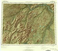 1952 Kantishna River1957 Print · USGSAlaska's interior wilderness in the early fifties was a landscape of remote river outposts and seasonal transit routes. Researchers can trace the decline of early settlements like Toklat and Nineteenmile or locate the historic Sled Road and Manley Hot Springs.7 unique versions available
 - 1952 Map of Kantishna River B-1, 1957 Print
 1952 Kantishna River B-11957 Print · USGSThe Alaska Interior near the confluence of major glacial rivers is captured here in the early fifties. Researchers can trace the winding paths of the Kantishna River and Toklat River to locate remote Cabins and the settlement at Toklat.3 unique versions available
 - 1964 Map of Kantishna River
 1964 Kantishna River1964 Print · USGSThe Alaska interior at the height of the Cold War reveals a river-dependent landscape where winter transport was still vital. Researchers can trace the Sled Road network and find former settlements like Toklat and Nineteenmile.
 - 2017 Map of Kantishna River B-1 NW, 2017 Print
 2017 Kantishna River B-1 NW2017 Print · USGSCovers Toklat, including Unorganized Borough, United States, and other nearby areas
 - 2024 Map of Kantishna River B-1 NW, 2024 Print
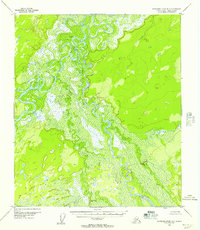
 2024 Kantishna River B-1 NW2024 Print · USGSThe interior of Alaska's Yukon-Koyukuk region is defined here by its massive, braided waterways as they appeared in the early 21st century. Researchers can trace the complex oxbows of the Kantishna River and Toklat River, or locate the isolated settlement of Toklat.
End of results
Showing maps 1-7 of 7
Frequently asked questions
- What are the different types of historical maps available for Toklat?
- What is the oldest map of Toklat?
- Where can I purchase historical maps of Toklat for my home or office?
- Where can I download high-res historical maps of Toklat?
- Are there historical topographic maps available for Toklat?
- Is there historical aerial imagery available for Toklat?
- Where are historical maps of Toklat sourced from?