1900s (20th Century) Maps of Toklat, Alaska
Explore 5 historic maps of Toklat from the 1900s (20th Century). These maps offer a rare glimpse into what life looked like during the 1900s — showing old roads, neighborhoods, homes, and landmarks that have changed or disappeared over time.
Whether you're researching your family's past, planning a metal detecting trip, or studying how Toklat's landscape evolved across the 1900s, these high-resolution maps are a powerful tool for exploring the history of this region.
- Focus on a specific era: All maps on this page are from the 1900s, giving you a focused view of this time period.
- See what’s changed: Compare century-old streets, trails, and buildings to today's modern landscape using overlays and satellite layers.
- Research with precision: Use these maps for genealogy, historical research, land use analysis, or educational projects.
- View, download, or print: Maps are fully viewable online in high resolution, and can be downloaded or printed for your own records.
Start exploring Toklat's history through authentic maps from the 1900s. This is your window into the past.
Toklat, AK maps
(5)- 1948 Map of Kantishna River, 1956 Print
 1948 Kantishna River1956 Print · USGSInterior Alaska during the late 1940s remained a frontier of river landings and winter trails before the era of major highway expansion. Genealogists and historians can trace the remote outposts of Manley Hot Springs Po, Roosevelt, and Toklat along the vast Kantishna River system.
 - 1951 Map of Kantishna River
 1951 Kantishna River1951 Print · USGSMid-century Alaska interior life is centered on river navigation and remote outposts like Manley Hot Springs and Roosevelt in the early 1950s. Researchers can trace historic transportation routes including a Sled Road and the Hot Springs Landing along the Tanana River.
 - 1952 Map of Kantishna River, 1957 Print
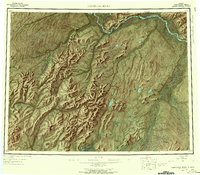 1952 Kantishna River1957 Print · USGSAlaska's interior wilderness in the early fifties was a landscape of remote river outposts and seasonal transit routes. Researchers can trace the decline of early settlements like Toklat and Nineteenmile or locate the historic Sled Road and Manley Hot Springs.7 unique versions available
 - 1952 Map of Kantishna River B-1, 1957 Print
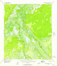 1952 Kantishna River B-11957 Print · USGSThe Alaska Interior near the confluence of major glacial rivers is captured here in the early fifties. Researchers can trace the winding paths of the Kantishna River and Toklat River to locate remote Cabins and the settlement at Toklat.3 unique versions available
 - 1964 Map of Kantishna River
 1964 Kantishna River1964 Print · USGSThe Alaska interior at the height of the Cold War reveals a river-dependent landscape where winter transport was still vital. Researchers can trace the Sled Road network and find former settlements like Toklat and Nineteenmile.
End of results
Showing maps 1-5 of 5
Frequently asked questions
- What are the different types of historical maps available for Toklat?
- What is the oldest map of Toklat?
- Where can I purchase historical maps of Toklat for my home or office?
- Where can I download high-res historical maps of Toklat?
- Are there historical topographic maps available for Toklat?
- Is there historical aerial imagery available for Toklat?
- Where are historical maps of Toklat sourced from?