1960s Maps of Valdez, Alaska
Explore 4 historic maps of Valdez from the 1960s. These maps offer a rare glimpse into what life looked like during the 1960s — showing old roads, neighborhoods, homes, and landmarks that have changed or disappeared over time.
Whether you're researching your family's past, planning a metal detecting trip, or studying how Valdez's landscape evolved across the 1960s, these high-resolution maps are a powerful tool for exploring the history of this region.
- Focus on a specific era: All maps on this page are from the 1960s, giving you a focused view of this time period.
- See what’s changed: Compare century-old streets, trails, and buildings to today's modern landscape using overlays and satellite layers.
- Research with precision: Use these maps for genealogy, historical research, land use analysis, or educational projects.
- View, download, or print: Maps are fully viewable online in high resolution, and can be downloaded or printed for your own records.
Start exploring Valdez's history through authentic maps from the 1960s. This is your window into the past.
Valdez, AK maps
(4)- 1960 Map of Valdez A-8, 1963 Print
 1960 Valdez A-81963 Print · USGSPrince William Sound at the start of the 1960s shows a landscape of massive ice fields and deep maritime inlets. Trace the glacial reaches of the Columbia Glacier and navigate coastal landmarks like Potato Pt and Middle Rock Light.3 unique versions available
 - 1960 Map of Valdez B-7, 1964 Print
 1960 Valdez B-71964 Print · USGSThe high Chugach Mountains ice fields were meticulously documented in the 1960s, capturing the state of massive glaciers during a period of relative stability. Researchers and alpinists can trace the extent of the Columbia Glacier and Valdez Glacier or locate summits like Mount Logan.
 - 1960 Map of Valdez A-7, 1965 Print
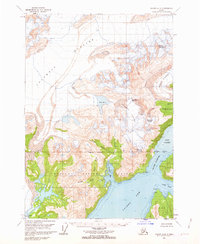
 1960 Valdez A-71965 Print · USGSThe port of Valdez and its surrounding mining districts are captured here in the early sixties, prior to the transformative 1964 earthquake. Researchers can trace the town's original layout, the Richardson Highway, and numerous lode sites like the Midas Mine and Cliff Mine.3 unique versions available
 - 1960 Map of Valdez, 1967 Print
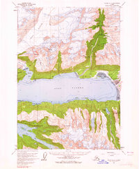
 1960 Valdez1967 Print · USGSCoastal and interior Alaska meet in this mid-century study of the Chugach Mountains and the copper-rich river valleys. Trace the legacy of early industry along the Copper River and Northwestern Railroad and locate settlements like Copper Center, Chitina, and Fort Liscum.6 unique versions available
End of results
Showing maps 1-4 of 4
Top neighborhoods of Valdez
Frequently asked questions
- What are the different types of historical maps available for Valdez?
- What is the oldest map of Valdez?
- Where can I purchase historical maps of Valdez for my home or office?
- Where can I download high-res historical maps of Valdez?
- Are there historical topographic maps available for Valdez?
- Is there historical aerial imagery available for Valdez?
- Where are historical maps of Valdez sourced from?