1960s Maps of Northwoods, Arizona
Explore 2 historic maps of Northwoods from the 1960s. These maps offer a rare glimpse into what life looked like during the 1960s — showing old roads, neighborhoods, homes, and landmarks that have changed or disappeared over time.
Whether you're researching your family's past, planning a metal detecting trip, or studying how Northwoods's landscape evolved across the 1960s, these high-resolution maps are a powerful tool for exploring the history of this region.
- Focus on a specific era: All maps on this page are from the 1960s, giving you a focused view of this time period.
- See what’s changed: Compare century-old streets, trails, and buildings to today's modern landscape using overlays and satellite layers.
- Research with precision: Use these maps for genealogy, historical research, land use analysis, or educational projects.
- View, download, or print: Maps are fully viewable online in high resolution, and can be downloaded or printed for your own records.
Start exploring Northwoods's history through authentic maps from the 1960s. This is your window into the past.
Northwoods, AZ maps
(2)- 1962 Map of Saint Johns
 1962 Saint Johns1962 Print · USGSEastern Arizona and the New Mexico borderlands come alive in the early sixties, showing a landscape of high-plateau ranching and early national monuments. Trace the path of the Atchison Topeka and Santa Fe or locate old water sources like Salado Springs and Lyman Reservoir.
 - 1969 Map of Greer, 1972 Print
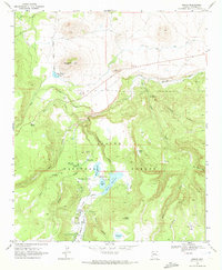 1969 Greer1972 Print · USGSHigh in the White Mountains during the late sixties, this survey shows the complex water systems and recreation areas of the Apache National Forest. Researchers can trace the development of the Greer Lakes and locate sites like Fish Creek Corral and the Hoyer Memorial Campground.2 unique versions available
End of results
Showing maps 1-2 of 2
Top cities near Northwoods
Frequently asked questions
- What are the different types of historical maps available for Northwoods?
- What is the oldest map of Northwoods?
- Where can I purchase historical maps of Northwoods for my home or office?
- Where can I download high-res historical maps of Northwoods?
- Are there historical topographic maps available for Northwoods?
- Is there historical aerial imagery available for Northwoods?
- Where are historical maps of Northwoods sourced from?