1980s Maps of Paulcell Place, Arizona
Explore 2 historic maps of Paulcell Place from the 1980s. These maps offer a rare glimpse into what life looked like during the 1980s — showing old roads, neighborhoods, homes, and landmarks that have changed or disappeared over time.
Whether you're researching your family's past, planning a metal detecting trip, or studying how Paulcell Place's landscape evolved across the 1980s, these high-resolution maps are a powerful tool for exploring the history of this region.
- Focus on a specific era: All maps on this page are from the 1980s, giving you a focused view of this time period.
- See what’s changed: Compare century-old streets, trails, and buildings to today's modern landscape using overlays and satellite layers.
- Research with precision: Use these maps for genealogy, historical research, land use analysis, or educational projects.
- View, download, or print: Maps are fully viewable online in high resolution, and can be downloaded or printed for your own records.
Start exploring Paulcell Place's history through authentic maps from the 1980s. This is your window into the past.
Paulcell Place, AZ maps
(2)- 1981 Map of Saint Johns, 1996 Print
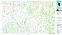 1981 Saint Johns1996 Print · USGSNortheastern Arizona's high plateau comes into focus in the early 1980s, centered on the settlement of St Johns. Researchers can trace the Atchison Topeka and Santa Fe railroad through Adamana and locate landmarks like Lyman Lake and Zion Reservoir.
 - 1982 Map of Adamana, 1983 Print
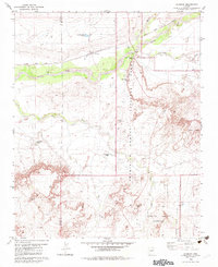 1982 Adamana1983 Print · USGSNortheastern Arizona's high desert is captured here in the early eighties, showing where the transcontinental railroad meets the ancient archaeology of the Painted Desert. Researchers can locate the settlement of Adamana alongside Puerco Indian Ruins and landmarks like Newspaper Rock.
End of results
Showing maps 1-2 of 2
Top cities near Paulcell Place
Frequently asked questions
- What are the different types of historical maps available for Paulcell Place?
- What is the oldest map of Paulcell Place?
- Where can I purchase historical maps of Paulcell Place for my home or office?
- Where can I download high-res historical maps of Paulcell Place?
- Are there historical topographic maps available for Paulcell Place?
- Is there historical aerial imagery available for Paulcell Place?
- Where are historical maps of Paulcell Place sourced from?