1981 Map of Saint Johns
USGS Topo · Published 1996About this map
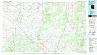
The high desert landscape of Petrified Forest National Park and the surrounding plateau dominate this 1981 survey of northeastern Arizona. Centered on the community of St Johns, the topography reveals a complex network of seasonal drainages and permanent water features, including the Colorado River and the Zuni River. The presence of Lyman Lake and Zion Reservoir indicates the critical role of water management in this arid region.
Find a feature on this map
41 named features on this map. Tap any name to fly to it.
Don’t see what you’re looking for? This feature index may not catch every label — zoom into the map to look around manually.
Map Details
Editions of this 1981 Saint Johns Map
This is the sole edition of this map. No revisions or reprints were ever made.
Other maps of this area

1883 · Tusayan
USGS Topo · 1:250,000

1886 · St Johns
USGS Topo · 1:250,000

1886 · Wingate
USGS Topo · 1:250,000

1886 · Tusayan
USGS Topo · 1:250,000

1886 · Fort Defiance
USGS Topo · 1:250,000

1886 · Holbrook
USGS Topo · 1:250,000

1892 · Fort Defiance
USGS Topo · 1:250,000

1892 · St Johns
USGS Topo · 1:250,000

1892 · Wingate
USGS Topo · 1:250,000

1893 · Holbrook
USGS Topo · 1:250,000