1900s (20th Century) Maps of St. Johns, Arizona
Explore 12 historic maps of St. Johns from the 1900s (20th Century). These maps offer a rare glimpse into what life looked like during the 1900s — showing old roads, neighborhoods, homes, and landmarks that have changed or disappeared over time.
Whether you're researching your family's past, planning a metal detecting trip, or studying how St. Johns's landscape evolved across the 1900s, these high-resolution maps are a powerful tool for exploring the history of this region.
- Focus on a specific era: All maps on this page are from the 1900s, giving you a focused view of this time period.
- See what’s changed: Compare century-old streets, trails, and buildings to today's modern landscape using overlays and satellite layers.
- Research with precision: Use these maps for genealogy, historical research, land use analysis, or educational projects.
- View, download, or print: Maps are fully viewable online in high resolution, and can be downloaded or printed for your own records.
Start exploring St. Johns's history through authentic maps from the 1900s. This is your window into the past.
St. Johns, AZ maps
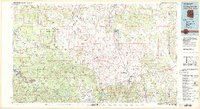
(12)- 1954 Map of Saint Johns, 1968 Print
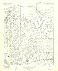
 1954 Saint Johns1968 Print · USGSThe high plateau of the Arizona-New Mexico border is captured here in the mid-1950s, showing the intersection of tribal lands and national forests. Researchers can trace the cattle country and mountain outposts from Saint Johns to Pie Town and McNary.3 unique versions available
 - 1955 Map of Wolford Springs 3 SW, 1957 Print
 1955 Wolford Springs 3 SW1957 Print · USGSThe high desert of Apache County comes into focus in the mid-fifties, centered on the Little Colorado River valley. Genealogists and historians can locate early homesteads like the Jolley Place, the infrastructure of the Zion Reservoir, and the outskirts of St Johns.
 - 1957 Map of Saint Johns
 1957 Saint Johns1957 Print · USGSThe Arizona-New Mexico borderlands are captured here in the mid-fifties, showing the high-country settlements and federal lands before modern development. Genealogists and historians can trace old homesteads and landmarks like the Red Hill Post Office, Lyman Reservoir, and the mountain communities of Eagar and Springerville.
 - 1958 Map of Saint Johns
 1958 Saint Johns1958 Print · USGSEastern Arizona and western New Mexico appear here in the late fifties, showcasing the high plateau and forest landscapes along the Continental Divide. Researchers can trace early ranching routes and water systems like Lyman Reservoir or locate remote settlements such as Fence Lake and Atarque.2 unique versions available
 - 1962 Map of Saint Johns
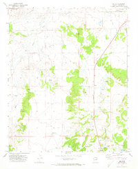
 1962 Saint Johns1962 Print · USGSEastern Arizona and the New Mexico borderlands come alive in the early sixties, showing a landscape of high-plateau ranching and early national monuments. Trace the path of the Atchison Topeka and Santa Fe or locate old water sources like Salado Springs and Lyman Reservoir.
 - 1971 Map of Salado, 1973 Print
 1971 Salado1973 Print · USGSApache County ranchlands in the early 1970s reveal a landscape of irrigation ditches and isolated outposts along the Little Colorado River. Genealogists and historians can trace family sites like Chavez Ranch, find the El Tule site, or locate the remote Cem and Salado Springs.2 unique versions available
 - 1971 Map of St. Johns South, 1973 Print
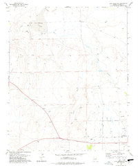
 1971 St. Johns South1973 Print · USGSThe southern fringes of St Johns and the surrounding high desert are captured here during the early seventies. Genealogists and researchers can trace local water management and early industry via the Little Reservoir, Diversion Dam, and several local Borrow Pits.2 unique versions available
 - 1974 Map of St. Johns North, 1984 Print
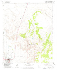
 1974 St. Johns North1984 Print · USGSThe town of St Johns sits along the Little Colorado River in the mid-1970s. Local history researchers can trace the neighborhood around Pioneer Sch, the East Side Cem, and the industrial Powerplant.
 - 1977 Map of St. Johns North, 1978 Print
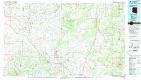
 1977 St. Johns North1978 Print · USGSThe northern edge of St Johns is captured here during the mid-1970s, showing the town at the intersection of the desert and the Little Colorado River. Genealogists and local historians can trace specific properties near the Coronado Sch, the East Side Cem, and the St Johns Airport.
 - 1978 Map of Zion Reservoir
 1978 Zion Reservoir1978 Print · USGSThe high desert landscape around the Little Colorado River shows its transition into a managed agricultural hub during the late seventies. Researchers can trace irrigation networks like the Upper Lyman Ditch and locate landmarks such as Heap Place or the St Johns Airport.2 unique versions available
 - 1981 Map of Springerville, 1982 Print
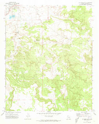
 1981 Springerville1982 Print · USGSThe high-country settlements of eastern Arizona come into focus during the early eighties, from the timber towns of Lakeside and Pinetop to the ranching center of Springerville. Trace family roots in McNary and Eagar or locate historic landmarks like the Williams Creek National Fish Hatchery.2 unique versions available
 - 1981 Map of Saint Johns, 1996 Print
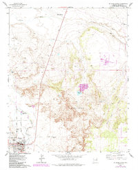
 1981 Saint Johns1996 Print · USGSNortheastern Arizona's high plateau comes into focus in the early 1980s, centered on the settlement of St Johns. Researchers can trace the Atchison Topeka and Santa Fe railroad through Adamana and locate landmarks like Lyman Lake and Zion Reservoir.
End of results
Showing maps 1-12 of 12
Frequently asked questions
- What are the different types of historical maps available for St. Johns?
- What is the oldest map of St. Johns?
- Where can I purchase historical maps of St. Johns for my home or office?
- Where can I download high-res historical maps of St. Johns?
- Are there historical topographic maps available for St. Johns?
- Is there historical aerial imagery available for St. Johns?
- Where are historical maps of St. Johns sourced from?