1980s Maps of St. Johns, Arizona
Explore 2 historic maps of St. Johns from the 1980s. These maps offer a rare glimpse into what life looked like during the 1980s — showing old roads, neighborhoods, homes, and landmarks that have changed or disappeared over time.
Whether you're researching your family's past, planning a metal detecting trip, or studying how St. Johns's landscape evolved across the 1980s, these high-resolution maps are a powerful tool for exploring the history of this region.
- Focus on a specific era: All maps on this page are from the 1980s, giving you a focused view of this time period.
- See what’s changed: Compare century-old streets, trails, and buildings to today's modern landscape using overlays and satellite layers.
- Research with precision: Use these maps for genealogy, historical research, land use analysis, or educational projects.
- View, download, or print: Maps are fully viewable online in high resolution, and can be downloaded or printed for your own records.
Start exploring St. Johns's history through authentic maps from the 1980s. This is your window into the past.
St. Johns, AZ maps
(2)- 1981 Map of Springerville, 1982 Print
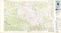 1981 Springerville1982 Print · USGSThe high-country settlements of eastern Arizona come into focus during the early eighties, from the timber towns of Lakeside and Pinetop to the ranching center of Springerville. Trace family roots in McNary and Eagar or locate historic landmarks like the Williams Creek National Fish Hatchery.2 unique versions available
 - 1981 Map of Saint Johns, 1996 Print
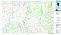 1981 Saint Johns1996 Print · USGSNortheastern Arizona's high plateau comes into focus in the early 1980s, centered on the settlement of St Johns. Researchers can trace the Atchison Topeka and Santa Fe railroad through Adamana and locate landmarks like Lyman Lake and Zion Reservoir.
End of results
Showing maps 1-2 of 2
Frequently asked questions
- What are the different types of historical maps available for St. Johns?
- What is the oldest map of St. Johns?
- Where can I purchase historical maps of St. Johns for my home or office?
- Where can I download high-res historical maps of St. Johns?
- Are there historical topographic maps available for St. Johns?
- Is there historical aerial imagery available for St. Johns?
- Where are historical maps of St. Johns sourced from?