1900s (20th Century) Maps of Wheatfields, Chinle Agency
Explore 7 historic maps of Wheatfields from the 1900s (20th Century). These maps offer a rare glimpse into what life looked like during the 1900s — showing old roads, neighborhoods, homes, and landmarks that have changed or disappeared over time.
Whether you're researching your family's past, planning a metal detecting trip, or studying how Wheatfields's landscape evolved across the 1900s, these high-resolution maps are a powerful tool for exploring the history of this region.
- Focus on a specific era: All maps on this page are from the 1900s, giving you a focused view of this time period.
- See what’s changed: Compare century-old streets, trails, and buildings to today's modern landscape using overlays and satellite layers.
- Research with precision: Use these maps for genealogy, historical research, land use analysis, or educational projects.
- View, download, or print: Maps are fully viewable online in high resolution, and can be downloaded or printed for your own records.
Start exploring Wheatfields's history through authentic maps from the 1900s. This is your window into the past.
Wheatfields, Chinle Agency maps
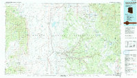
(7)- 1954 Map of Shiprock
 1954 Shiprock1954 Print · USGSThe Four Corners region in the mid-fifties reveals a vast landscape of tribal lands and desert landmarks. Researchers can trace the mid-century footprints of the Navajo Indian Reservation, identifying remote Trading Posts, the early growth of Farmington, and the iconic spire of Ship Rock.5 unique versions available
 - 1955 Map of Sonsala Butte 4 NW, 1958 Print
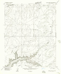 1955 Sonsala Butte 4 NW1958 Print · USGSThe Navajo Indian Reservation and the high Defiance Plateau are captured here in the mid-fifties, showing the rugged approach to the Canyon De Chelly. Researchers can locate the settlement at Lower Wheatfields, a lone Grave, and the seasonal flows of Whiskey Creek.
 - 1955 Map of Sonsela Buttes, 1959 Print
 1955 Sonsela Buttes1959 Print · USGSThe high plateau of the Navajo Nation comes to life in the mid-fifties, spanning the border between Arizona and New Mexico. Researchers can trace land use at Chee Dodge Ranch and follow old routes through Lower Wheatfields or the Beshthalthaa Cliffs.3 unique versions available
 - 1958 Map of Shiprock
 1958 Shiprock1958 Print · USGSThe Four Corners region in the mid-fifties shows a vast network of remote outposts and river settlements. You can locate numerous historic sites like the Emmanuel Mission and several commercial hubs such as Burnham Trading Post and Bisti Trading Post.
 - 1959 Map of Shiprock
 1959 Shiprock1959 Print · USGSThe Four Corners region comes alive in the mid-fifties, showing the high desert outposts and river-valley towns of the Navajo Nation and San Juan County. Genealogists and researchers can locate remote landmarks like the Burnham Trading Post, Two Grey Hills, and the early Helium Plant.
 - 1983 Map of Lower Wheatfields
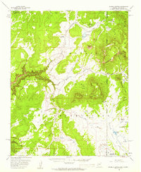
 1983 Lower Wheatfields1983 Print · USGSThe Navajo Nation high country is documented in the early eighties, showing the essential water systems and community centers of the plateau. Genealogists and historians can trace local landmarks like Wheatfields, the Wheatfields Chapter House, and the Canyon De Chelly National Monument boundary.
 - 1984 Map of Canyon De Chelly
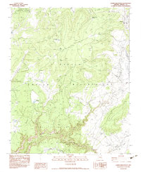
 1984 Canyon De Chelly1984 Print · USGSThe Navajo heartland in the mid-eighties shows a landscape of deep canyons and high mesas at a time of rising educational and civic infrastructure. Genealogists and researchers can locate remote trading posts like Upper Greasewood Trading Post and early campus buildings at Navajo Community College.
End of results
Showing maps 1-7 of 7
Top cities near Wheatfields
- Shiprock Agency historical maps
- Chinle Agency historical maps
- Fort Defiance Agency historical maps
- Eastern Navajo Agency historical maps
Frequently asked questions
- What are the different types of historical maps available for Wheatfields?
- What is the oldest map of Wheatfields?
- Where can I purchase historical maps of Wheatfields for my home or office?
- Where can I download high-res historical maps of Wheatfields?
- Are there historical topographic maps available for Wheatfields?
- Is there historical aerial imagery available for Wheatfields?
- Where are historical maps of Wheatfields sourced from?