1900s (20th Century) Maps of Cazador, Arizona
Explore 10 historic maps of Cazador from the 1900s (20th Century). These maps offer a rare glimpse into what life looked like during the 1900s — showing old roads, neighborhoods, homes, and landmarks that have changed or disappeared over time.
Whether you're researching your family's past, planning a metal detecting trip, or studying how Cazador's landscape evolved across the 1900s, these high-resolution maps are a powerful tool for exploring the history of this region.
- Focus on a specific era: All maps on this page are from the 1900s, giving you a focused view of this time period.
- See what’s changed: Compare century-old streets, trails, and buildings to today's modern landscape using overlays and satellite layers.
- Research with precision: Use these maps for genealogy, historical research, land use analysis, or educational projects.
- View, download, or print: Maps are fully viewable online in high resolution, and can be downloaded or printed for your own records.
Start exploring Cazador's history through authentic maps from the 1900s. This is your window into the past.
Cazador, AZ maps
(10)- 1919 Map of Perilla
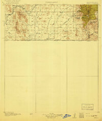 1919 Perilla1919 Print · USGSThe Arizona-Mexico borderlands come alive in this survey of the high desert ranching country. Genealogists and historians can trace family operations like the McDonald Ranch and Ed Howard Ranch, or locate the Cottonwood Creek School and Cazador Siding along the old rail line.4 unique versions available
 - 1940 Map of College Peaks
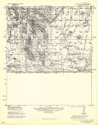 1940 College Peaks1940 Print · USGSThe Arizona-Mexico border comes alive in this pre-war survey of the high desert and cattle country. Genealogists and historians can trace the vast San Bernardino Grant and family outposts like Slaughters Ranch San Bernardino or the Ed Howard Ranch.
 - 1955 Map of Douglas
 1955 Douglas1955 Print · USGSThe Arizona and New Mexico borderlands come into focus in the mid-1950s, highlighting the mining and ranching hubs of the Desert Southwest. Genealogists and historians can trace the foundations of Bisbee, the operations at Hachita Mine, and rural landmarks like the Double Adobe School.2 unique versions available
 - 1958 Map of College Peaks, 1959 Print
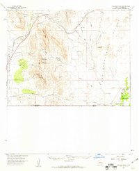 1958 College Peaks1959 Print · USGSSoutheast Arizona's high desert borderlands are captured here in the late fifties, showing a landscape defined by cattle ranching and rugged mountain passes. Genealogists and historians can trace family-named water sources like Steel Woods Windmill and landmarks along the historic Geronimo Trail.3 unique versions available
 - 1959 Map of Douglas, 1968 Print
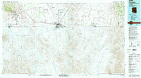
 1959 Douglas1968 Print · USGSSoutheast Arizona and southwest New Mexico meet at the border in the late fifties, showcasing a high-desert landscape defined by industrial copper mining and ranching. Genealogists and historians can trace the foundations of Bisbee, locate the Lavender Pit, and follow the Southern Pacific line through Douglas.4 unique versions available
 - 1961 Map of Douglas
 1961 Douglas1961 Print · USGSThe Arizona-Mexico borderlands come into focus at mid-century, detailing the vital mining and ranching hubs of Cochise County and southwest New Mexico. Genealogists and historians can trace the Southern Pacific Railroad through Bisbee and Douglas, or locate early sites like the Old Hachita Mine and Rucker School.
 - 1964 Map of Douglas
 1964 Douglas1964 Print · USGSThe Arizona-New Mexico borderlands in the early sixties reveal a landscape of deep-rooted copper mining and high-desert ranching. Genealogists and researchers can trace the legacy of settlements like Pirtleville, the industrial site of the Copper Smelter, and remnants of the Cochise Mines.
 - 1985 Map of College Peaks, 1986 Print
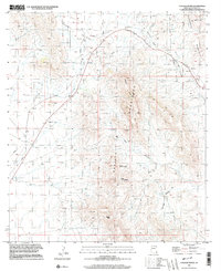
 1985 College Peaks1986 Print · USGSCochise County ranching and mining lands are captured here during the mid-1980s as the landscape transitioned toward modern use. Trace the path of an Old RR Grade or locate remote water sources like Bass Tank and the Cem near Poverty Flat.
 - 1994 Map of Douglas
 1994 Douglas1994 Print · USGSThe copper mining heart of Cochise County and the international border are captured here in the mid-nineties. Researchers can trace the massive Lavender Pit at Bisbee or locate rural landmarks like Paul Spur and the San Bernardino National Wildlife Refuge.2 unique versions available
 - 1996 Map of College Peaks, 2003 Print
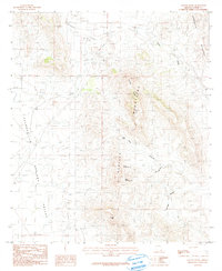
 1996 College Peaks2003 Print · USGSCochise County high desert is mapped here in the late twentieth century, showing the intersection of mountain ranges and early transport. Trace old mining and ranching history through landmarks like the Old Grade Railroad, Upper Tincup Spring, and a lonely Cem.
End of results
Showing maps 1-10 of 10
Top cities near Cazador
Frequently asked questions
- What are the different types of historical maps available for Cazador?
- What is the oldest map of Cazador?
- Where can I purchase historical maps of Cazador for my home or office?
- Where can I download high-res historical maps of Cazador?
- Are there historical topographic maps available for Cazador?
- Is there historical aerial imagery available for Cazador?
- Where are historical maps of Cazador sourced from?