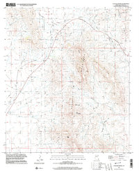
1996 Map of College Peaks
USGS Topo · Published 2003About this map
The Perilla Mountains and Pedregosa Mountains converge in this high-desert region of Cochise County, defined by a network of seasonal water sources and early transport routes. The Old Grade Railroad cuts through the western landscape, passing near the broad expanse of Poverty Flat. This area illustrates the critical importance of water in the arid Southwest, with several named sources like Upper Tincup Spring and Georges Spring providing essential resources for livestock and early travelers. Local history and industry are represented by a Cem tucked away in the northern foothills and various small-scale operations including a Quarry and several Prospects. The rugged terrain is further articulated by features such as Hog Canyon and the prominent Saddle Gap, which serve as natural landmarks and passage points between the peaks.
Find a feature on this map
17 named features on this map. Tap any name to fly to it.
Don’t see what you’re looking for? This feature index may not catch every label — zoom into the map to look around manually.
Map Details
Editions of this 1996 College Peaks Map
This is the sole edition of this map. No revisions or reprints were ever made.
Other maps of this area

1914 · Douglas
USGS Topo · 1:62,500

1916 · Pearce
USGS Topo · 1:125,000

1916 · Douglas
USGS Topo · 1:125,000

1917 · Chiricahua
USGS Topo · 1:125,000

1919 · Douglas
USGS Topo · 1:125,000

1919 · Perilla
USGS Topo · 1:125,000

1919 · Chiricahua
USGS Topo · 1:125,000

1922 · Swisshelm
USGS Topo · 1:62,500

1925 · Douglas
USGS Topo · 1:62,500

1926 · Pedregosa
USGS Topo · 1:62,500