1990s Maps of Chamiso, Arizona
Explore 2 historic maps of Chamiso from the 1990s. These maps offer a rare glimpse into what life looked like during the 1990s — showing old roads, neighborhoods, homes, and landmarks that have changed or disappeared over time.
Whether you're researching your family's past, planning a metal detecting trip, or studying how Chamiso's landscape evolved across the 1990s, these high-resolution maps are a powerful tool for exploring the history of this region.
- Focus on a specific era: All maps on this page are from the 1990s, giving you a focused view of this time period.
- See what’s changed: Compare century-old streets, trails, and buildings to today's modern landscape using overlays and satellite layers.
- Research with precision: Use these maps for genealogy, historical research, land use analysis, or educational projects.
- View, download, or print: Maps are fully viewable online in high resolution, and can be downloaded or printed for your own records.
Start exploring Chamiso's history through authentic maps from the 1990s. This is your window into the past.
Chamiso, AZ maps
(2)- 1994 Map of Fort Huachuca
 1994 Fort Huachuca1994 Print · USGSSouthern Arizona in the mid-nineties shows a landscape of expansive military reservations, historic land grants, and storied mining districts. Researchers can trace the S P RR through the San Pedro River valley or locate dozens of remote mountain workings like the Montezuma Mine and Eureka Mine.3 unique versions available
 - 1996 Map of Benson, 2002 Print
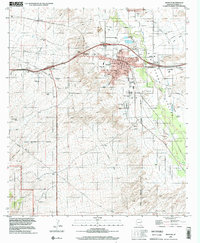 1996 Benson2002 Print · USGSThe San Pedro Valley during the late twentieth century shows the growth of Benson from a rail town into a regional center. Genealogists and historians can trace the Benson Cem, local schools, and outlying settlements like Chamiso or Pomerene.
End of results
Showing maps 1-2 of 2
Top cities near Chamiso
Frequently asked questions
- What are the different types of historical maps available for Chamiso?
- What is the oldest map of Chamiso?
- Where can I purchase historical maps of Chamiso for my home or office?
- Where can I download high-res historical maps of Chamiso?
- Are there historical topographic maps available for Chamiso?
- Is there historical aerial imagery available for Chamiso?
- Where are historical maps of Chamiso sourced from?