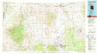
1994 Map of Fort Huachuca
USGS Topo · Published 1994About this map
The Fort Huachuca Military Reservation dominates the southeastern portion of this landscape, reflecting a region defined by extensive military, ranching, and mining history. Several large Spanish land grants, including the Luis Maria Baca Grant (Float No 3) and the San Ignacio Del Babocomari Grant, partition the territory between the Huachuca Mountains and the Santa Rita Mountains. The map documents a complex drainage network where the San Pedro River and Santa Cruz River flow north, supporting settlements like Saint David and Pomerene. High-elevation mining activity is evident through the naming of numerous operations such as the California Mine and Santa Cruz Mine. Meanwhile, the transition from rail to road is visible through the presence of the S P RR alongside an Old RR Grade near Fairbank and Charleston.
Find a feature on this map
92 named features on this map. Tap any name to fly to it.
Don’t see what you’re looking for? This feature index may not catch every label — zoom into the map to look around manually.
Map Details
Editions of this 1994 Fort Huachuca Map
3 editions found
Other maps of this area

1902 · Bisbee
USGS Topo · 1:62,500

1904 · Patagonia
USGS Topo · 1:125,000

1904 · Tucson
USGS Topo · 1:125,000

1905 · Patagonia
USGS Topo · 1:125,000

1905 · Tucson
USGS Topo · 1:125,000

1905 · Nogales
USGS Topo · 1:125,000

1910 · Bisbee
USGS Topo · 1:62,500

1914 · Hereford
USGS Topo · 1:125,000

1915 · Benson
USGS Topo · 1:125,000

1916 · Pearce
USGS Topo · 1:125,000