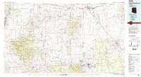
1994 Map of Fort Huachuca
USGS Topo · Published 1994About this map
The Fort Huachuca Military Reservation and the legendary town of Tombstone anchor this mid-1990s survey of Southern Arizona’s high desert and mountain ranges. The map traces the legacy of mining and military history from the Santa Rita Mountains in the west to the Dragoon Mountains in the east. Industrial footprints are visible at the Copper World Mine and Helvetia Mine, while the San Pedro River valley shows the corridor for the Southern Pacific RR and the San Pedro and Southwestern RR. These rail lines connected historic settlements such as Fairbank and Charleston. Modern infrastructure like Sierra Vista and the Sahuarita Air Force Range sits alongside protected lands including the Mt Wrightson Wilderness and the Santa Rita Experimental Range and Wildlife Area. The map reveals a landscape defined by sharp elevation changes, from the depths of Davidson Canyon to the peak of Mt Wrightson.
Find a feature on this map
81 named features on this map. Tap any name to fly to it.
Don’t see what you’re looking for? This feature index may not catch every label — zoom into the map to look around manually.
Map Details
Editions of this 1994 Fort Huachuca Map
3 editions found
Other maps of this area

1902 · Bisbee
USGS Topo · 1:62,500

1904 · Patagonia
USGS Topo · 1:125,000

1904 · Tucson
USGS Topo · 1:125,000

1905 · Patagonia
USGS Topo · 1:125,000

1905 · Tucson
USGS Topo · 1:125,000

1905 · Nogales
USGS Topo · 1:125,000

1910 · Bisbee
USGS Topo · 1:62,500

1914 · Hereford
USGS Topo · 1:125,000

1915 · Benson
USGS Topo · 1:125,000

1916 · Pearce
USGS Topo · 1:125,000