1990s Maps of Hilltop, Arizona
Explore 2 historic maps of Hilltop from the 1990s. These maps offer a rare glimpse into what life looked like during the 1990s — showing old roads, neighborhoods, homes, and landmarks that have changed or disappeared over time.
Whether you're researching your family's past, planning a metal detecting trip, or studying how Hilltop's landscape evolved across the 1990s, these high-resolution maps are a powerful tool for exploring the history of this region.
- Focus on a specific era: All maps on this page are from the 1990s, giving you a focused view of this time period.
- See what’s changed: Compare century-old streets, trails, and buildings to today's modern landscape using overlays and satellite layers.
- Research with precision: Use these maps for genealogy, historical research, land use analysis, or educational projects.
- View, download, or print: Maps are fully viewable online in high resolution, and can be downloaded or printed for your own records.
Start exploring Hilltop's history through authentic maps from the 1990s. This is your window into the past.
Hilltop, AZ maps
(2)- 1994 Map of Chiricahua Peak
 1994 Chiricahua Peak1994 Print · USGSSoutheast Arizona in the mid-nineties shows a land of high sky islands and broad cattle valleys transitioning into New Mexico. Trace the legacy of old mining camps and railroad stops from Pearce and Gleeson to the canyons of the Chiricahua Mountains.2 unique versions available
 - 1998 Map of Rustler Park, 2003 Print
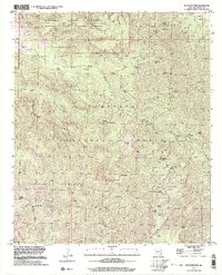 1998 Rustler Park2003 Print · USGSThe Chiricahua Mountains in southeastern Arizona are shown here in the late twentieth century as a landscape of protected wilderness and deep-rooted mining history. Researchers can trace historic extraction sites like the Silver Prince Mine or locate high-altitude landmarks including the Rustler Park Lookout and the Hilltop (Site).
End of results
Showing maps 1-2 of 2
Top cities near Hilltop
Frequently asked questions
- What are the different types of historical maps available for Hilltop?
- What is the oldest map of Hilltop?
- Where can I purchase historical maps of Hilltop for my home or office?
- Where can I download high-res historical maps of Hilltop?
- Are there historical topographic maps available for Hilltop?
- Is there historical aerial imagery available for Hilltop?
- Where are historical maps of Hilltop sourced from?