1980s Maps of Tusayan, Arizona
Explore 2 historic maps of Tusayan from the 1980s. These maps offer a rare glimpse into what life looked like during the 1980s — showing old roads, neighborhoods, homes, and landmarks that have changed or disappeared over time.
Whether you're researching your family's past, planning a metal detecting trip, or studying how Tusayan's landscape evolved across the 1980s, these high-resolution maps are a powerful tool for exploring the history of this region.
- Focus on a specific era: All maps on this page are from the 1980s, giving you a focused view of this time period.
- See what’s changed: Compare century-old streets, trails, and buildings to today's modern landscape using overlays and satellite layers.
- Research with precision: Use these maps for genealogy, historical research, land use analysis, or educational projects.
- View, download, or print: Maps are fully viewable online in high resolution, and can be downloaded or printed for your own records.
Start exploring Tusayan's history through authentic maps from the 1980s. This is your window into the past.
Tusayan, AZ maps
(2)- 1981 Map of Tusayan East
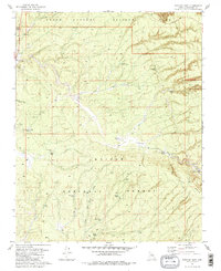 1981 Tusayan East1981 Print · USGSCoconino County’s southern approach to the Grand Canyon is captured here in the early eighties as the village of Tusayan grew alongside federal forest lands. Trace the network of cattle tanks and forest tracks like Ten X Wash and the Tusayan Ranger Station.2 unique versions available
 - 1983 Map of Valle
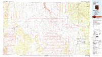 1983 Valle1983 Print · USGSThe Coconino Plateau in the early eighties shows a landscape of vital transit corridors and remote outposts. Trace the path of the Atchison Topeka and Santa Fe railroad or locate isolated landmarks like Rose Well Camp and the Copper Queen Mine.3 unique versions available
End of results
Showing maps 1-2 of 2
Top cities near Tusayan
Frequently asked questions
- What are the different types of historical maps available for Tusayan?
- What is the oldest map of Tusayan?
- Where can I purchase historical maps of Tusayan for my home or office?
- Where can I download high-res historical maps of Tusayan?
- Are there historical topographic maps available for Tusayan?
- Is there historical aerial imagery available for Tusayan?
- Where are historical maps of Tusayan sourced from?