1980s Maps of Wahweap, Arizona
Explore 2 historic maps of Wahweap from the 1980s. These maps offer a rare glimpse into what life looked like during the 1980s — showing old roads, neighborhoods, homes, and landmarks that have changed or disappeared over time.
Whether you're researching your family's past, planning a metal detecting trip, or studying how Wahweap's landscape evolved across the 1980s, these high-resolution maps are a powerful tool for exploring the history of this region.
- Focus on a specific era: All maps on this page are from the 1980s, giving you a focused view of this time period.
- See what’s changed: Compare century-old streets, trails, and buildings to today's modern landscape using overlays and satellite layers.
- Research with precision: Use these maps for genealogy, historical research, land use analysis, or educational projects.
- View, download, or print: Maps are fully viewable online in high resolution, and can be downloaded or printed for your own records.
Start exploring Wahweap's history through authentic maps from the 1980s. This is your window into the past.
Wahweap, AZ maps
(2)- 1984 Map of Glen Canyon Dam
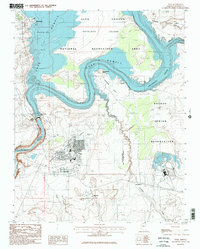
 1984 Glen Canyon Dam1984 Print · USGSThe Colorado River corridor near the Utah border is captured here in the mid-eighties, centered on the rise of modern infrastructure in the desert. Researchers can trace the development of Page alongside historic sites like Lees Ferry and the Copper Mine Trading Post.2 unique versions available
 - 1985 Map of Page, 1986 Print
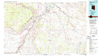
 1985 Page1986 Print · USGSThe high-desert city of Page is shown in the mid-1980s, serving as a hub for the Glen Canyon Dam and Navajo lands. Researchers can trace the layout of Page on Manson Mesa and identify local landmarks like the Municipal Airport, Wahweap, and the Glen Canyon Dam.2 unique versions available
End of results
Showing maps 1-2 of 2
Top cities near Wahweap
Frequently asked questions
- What are the different types of historical maps available for Wahweap?
- What is the oldest map of Wahweap?
- Where can I purchase historical maps of Wahweap for my home or office?
- Where can I download high-res historical maps of Wahweap?
- Are there historical topographic maps available for Wahweap?
- Is there historical aerial imagery available for Wahweap?
- Where are historical maps of Wahweap sourced from?