1970s Maps of Old Columbine, Arizona
Explore 1 historic maps of Old Columbine from the 1970s. These maps offer a rare glimpse into what life looked like during the 1970s — showing old roads, neighborhoods, homes, and landmarks that have changed or disappeared over time.
Whether you're researching your family's past, planning a metal detecting trip, or studying how Old Columbine's landscape evolved across the 1970s, these high-resolution maps are a powerful tool for exploring the history of this region.
- Focus on a specific era: All maps on this page are from the 1970s, giving you a focused view of this time period.
- See what’s changed: Compare century-old streets, trails, and buildings to today's modern landscape using overlays and satellite layers.
- Research with precision: Use these maps for genealogy, historical research, land use analysis, or educational projects.
- View, download, or print: Maps are fully viewable online in high resolution, and can be downloaded or printed for your own records.
Start exploring Old Columbine's history through authentic maps from the 1970s. This is your window into the past.
Old Columbine, AZ maps
(1)- 1972 Map of Webb Peak, 1975 Print
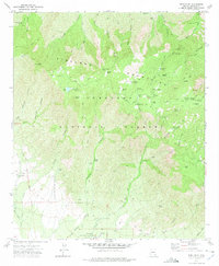 1972 Webb Peak1975 Print · USGSThe high peaks of the Pinaleno Mountains are captured here in the early 1970s as the area balanced forest management with recreation. Researchers can trace the layout of Fort Grant (State Industrial School) or locate the Mt Graham Mill Site and Arizona Bible Sch.4 unique versions available
End of results
Showing maps 1-1 of 1
Top cities near Old Columbine
- Safford historical maps
- Thatcher historical maps
- Pima historical maps
- Swift Trail Junction historical maps
- Cactus Flat historical maps
- Central historical maps
Frequently asked questions
- What are the different types of historical maps available for Old Columbine?
- What is the oldest map of Old Columbine?
- Where can I purchase historical maps of Old Columbine for my home or office?
- Where can I download high-res historical maps of Old Columbine?
- Are there historical topographic maps available for Old Columbine?
- Is there historical aerial imagery available for Old Columbine?
- Where are historical maps of Old Columbine sourced from?