1940s Maps of Old Columbine, Arizona
Explore 2 historic maps of Old Columbine from the 1940s. These maps offer a rare glimpse into what life looked like during the 1940s — showing old roads, neighborhoods, homes, and landmarks that have changed or disappeared over time.
Whether you're researching your family's past, planning a metal detecting trip, or studying how Old Columbine's landscape evolved across the 1940s, these high-resolution maps are a powerful tool for exploring the history of this region.
- Focus on a specific era: All maps on this page are from the 1940s, giving you a focused view of this time period.
- See what’s changed: Compare century-old streets, trails, and buildings to today's modern landscape using overlays and satellite layers.
- Research with precision: Use these maps for genealogy, historical research, land use analysis, or educational projects.
- View, download, or print: Maps are fully viewable online in high resolution, and can be downloaded or printed for your own records.
Start exploring Old Columbine's history through authentic maps from the 1940s. This is your window into the past.
Old Columbine, AZ maps
(2)- 1942 Map of Mt. Graham, 1945 Print
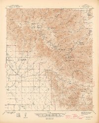 1942 Mt. Graham1945 Print · USGSThe Pinaleno Mountains rise sharply from the desert floor in the early 1940s, showing a landscape defined by forest service outposts and cattle ranches. Researchers can trace historic landmarks like Fort Grant (PO), the Columbine Ranger Station, and the winding Swift Trail.3 unique versions available
 - 1945 Map of Mt. Graham
 1945 Mt. Graham1945 Print · USGSGraham County ranching and forestry are captured here in the mid-1940s, from the valley floor to the high peaks. Genealogists can locate family landmarks like the Mills Ranch, Cluff Dairy, and the State Industrial School.
End of results
Showing maps 1-2 of 2
Top cities near Old Columbine
- Safford historical maps
- Thatcher historical maps
- Pima historical maps
- Swift Trail Junction historical maps
- Cactus Flat historical maps
- Central historical maps
Frequently asked questions
- What are the different types of historical maps available for Old Columbine?
- What is the oldest map of Old Columbine?
- Where can I purchase historical maps of Old Columbine for my home or office?
- Where can I download high-res historical maps of Old Columbine?
- Are there historical topographic maps available for Old Columbine?
- Is there historical aerial imagery available for Old Columbine?
- Where are historical maps of Old Columbine sourced from?