1980s Maps of Clifton, Arizona
Explore 3 historic maps of Clifton from the 1980s. These maps offer a rare glimpse into what life looked like during the 1980s — showing old roads, neighborhoods, homes, and landmarks that have changed or disappeared over time.
Whether you're researching your family's past, planning a metal detecting trip, or studying how Clifton's landscape evolved across the 1980s, these high-resolution maps are a powerful tool for exploring the history of this region.
- Focus on a specific era: All maps on this page are from the 1980s, giving you a focused view of this time period.
- See what’s changed: Compare century-old streets, trails, and buildings to today's modern landscape using overlays and satellite layers.
- Research with precision: Use these maps for genealogy, historical research, land use analysis, or educational projects.
- View, download, or print: Maps are fully viewable online in high resolution, and can be downloaded or printed for your own records.
Start exploring Clifton's history through authentic maps from the 1980s. This is your window into the past.
Clifton, AZ maps
(3)- 1986 Map of Guthrie
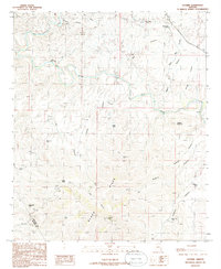 1986 Guthrie1986 Print · USGSEastern Arizona’s river valleys and mining districts are captured here in the mid-1980s. Local historians can trace the Smuggler Open Pit Mine, find the Gillard Hot Springs along the Gila River, and locate family-named landmarks like Wilkerson Tank.2 unique versions available
 - 1986 Map of Clifton, 1987 Print
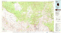 1986 Clifton1987 Print · USGSArizona's copper country and the rugged borderlands come into sharp focus in the mid-1980s. Researchers can trace the massive Morenci Open Pit and its rail connections to Clifton, alongside remote outposts like Point of Pines and Fort Thomas.2 unique versions available
 - 1989 Map of Clifton, 1990 Print
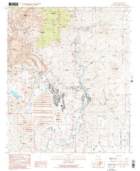 1989 Clifton1990 Print · USGSThe copper mining heart of Greenlee County comes alive in this late-century record of Clifton and the surrounding river canyons. Genealogists and researchers can trace old settlement sites and family history at Metcalf Cem and Bunkers Cem near the massive Morenci Pit.
End of results
Showing maps 1-3 of 3
Top neighborhoods of Clifton
Frequently asked questions
- What are the different types of historical maps available for Clifton?
- What is the oldest map of Clifton?
- Where can I purchase historical maps of Clifton for my home or office?
- Where can I download high-res historical maps of Clifton?
- Are there historical topographic maps available for Clifton?
- Is there historical aerial imagery available for Clifton?
- Where are historical maps of Clifton sourced from?