1940s Maps of Las Palmeras West, Avondale
Explore 2 historic maps of Las Palmeras West from the 1940s. These maps offer a rare glimpse into what life looked like during the 1940s — showing old roads, neighborhoods, homes, and landmarks that have changed or disappeared over time.
Whether you're researching your family's past, planning a metal detecting trip, or studying how Las Palmeras West's landscape evolved across the 1940s, these high-resolution maps are a powerful tool for exploring the history of this region.
- Focus on a specific era: All maps on this page are from the 1940s, giving you a focused view of this time period.
- See what’s changed: Compare century-old streets, trails, and buildings to today's modern landscape using overlays and satellite layers.
- Research with precision: Use these maps for genealogy, historical research, land use analysis, or educational projects.
- View, download, or print: Maps are fully viewable online in high resolution, and can be downloaded or printed for your own records.
Start exploring Las Palmeras West's history through authentic maps from the 1940s. This is your window into the past.
Las Palmeras West, Avondale maps
(2)- 1946 Map of Avondale, 1963 Print
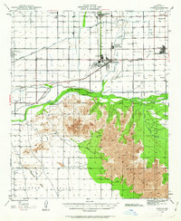 1946 Avondale1963 Print · USGSIn the postwar Salt River Valley, desert agriculture and military aviation began to reshape the landscape around Coldwater. Researchers can trace the early footprints of Litchfield Park, the U S Naval Air Facility, and rural sites like Liberty Siding.2 unique versions available
 - 1948 Map of Cashion
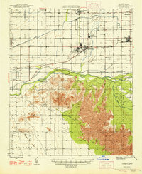 1948 Cashion1948 Print · USGSMaricopa County's western valley is captured here in the late 1940s as agricultural irrigation and military aviation began to reshape the desert. Researchers can locate early schools and aviation landmarks like Pendergast Sch, the U S Naval Air Facility, and the state's geographic Initial Point.2 unique versions available
End of results
Showing maps 1-2 of 2
Frequently asked questions
- What are the different types of historical maps available for Las Palmeras West?
- What is the oldest map of Las Palmeras West?
- Where can I purchase historical maps of Las Palmeras West for my home or office?
- Where can I download high-res historical maps of Las Palmeras West?
- Are there historical topographic maps available for Las Palmeras West?
- Is there historical aerial imagery available for Las Palmeras West?
- Where are historical maps of Las Palmeras West sourced from?