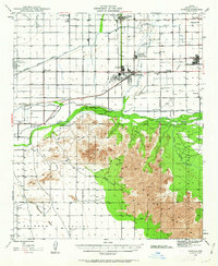
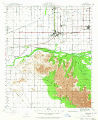
1946 Map of Avondale
USGS Topo · Published 1963About this map
The Agua Fria River and Gila River converge in this mid-century portrait of the Salt River Valley, where irrigation networks and military aviation transformed the desert. Agricultural growth is visible through the Roosevelt Irrigation District Canal and the Southern Pacific Buckeye Extension Canal, which supported settlements like Tolleson and Liberty. The era's defense footprint is prominent, featuring the Litchfield Airport and the adjacent U S Naval Air Facility. To the south, the massive peaks of the Sierra Estrella loom over Rainbow Valley, marking the boundary of the Gila River Indian Reservation. Local history details include rural centers like the Avondale Farm Labor Supply Center and neighborhood schools such as Littleton Sch and Pendergast Sch.
Find a feature on this map
34 named features on this map. Tap any name to fly to it.
Don’t see what you’re looking for? This feature index may not catch every label — zoom into the map to look around manually.
Map Details
Editions of this 1946 Avondale Map
2 editions found
Historical Maps of Phoenix Through Time
1 maps found