1970s Maps of Rancho de Arboleda, Mesa
Explore 2 historic maps of Rancho de Arboleda from the 1970s. These maps offer a rare glimpse into what life looked like during the 1970s — showing old roads, neighborhoods, homes, and landmarks that have changed or disappeared over time.
Whether you're researching your family's past, planning a metal detecting trip, or studying how Rancho de Arboleda's landscape evolved across the 1970s, these high-resolution maps are a powerful tool for exploring the history of this region.
- Focus on a specific era: All maps on this page are from the 1970s, giving you a focused view of this time period.
- See what’s changed: Compare century-old streets, trails, and buildings to today's modern landscape using overlays and satellite layers.
- Research with precision: Use these maps for genealogy, historical research, land use analysis, or educational projects.
- View, download, or print: Maps are fully viewable online in high resolution, and can be downloaded or printed for your own records.
Start exploring Rancho de Arboleda's history through authentic maps from the 1970s. This is your window into the past.
Rancho de Arboleda, Mesa maps
(2)- 1971 Map of Mesa, 1972 Print
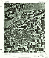 1971 Mesa1972 Print · USGSMesa in the early seventies shows the sharp contrast between its growing street grid and the surrounding agricultural tracts. Local historians can trace the mid-century footprint of Mesa and the natural course of the Salt River during this period of change.2 unique versions available
 - 1972 Map of Mesa, 1975 Print
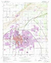 1972 Mesa1975 Print · USGSGreater Phoenix expanded rapidly in the early seventies, as shown in this detailed look at MESA and the Salt River. Local historians can trace early irrigation routes like the Consolidated Canal or find family connections at Lehi and the LDS Temple.
End of results
Showing maps 1-2 of 2
Frequently asked questions
- What are the different types of historical maps available for Rancho de Arboleda?
- What is the oldest map of Rancho de Arboleda?
- Where can I purchase historical maps of Rancho de Arboleda for my home or office?
- Where can I download high-res historical maps of Rancho de Arboleda?
- Are there historical topographic maps available for Rancho de Arboleda?
- Is there historical aerial imagery available for Rancho de Arboleda?
- Where are historical maps of Rancho de Arboleda sourced from?