1980s Maps of Saddle, Arizona
Explore 2 historic maps of Saddle from the 1980s. These maps offer a rare glimpse into what life looked like during the 1980s — showing old roads, neighborhoods, homes, and landmarks that have changed or disappeared over time.
Whether you're researching your family's past, planning a metal detecting trip, or studying how Saddle's landscape evolved across the 1980s, these high-resolution maps are a powerful tool for exploring the history of this region.
- Focus on a specific era: All maps on this page are from the 1980s, giving you a focused view of this time period.
- See what’s changed: Compare century-old streets, trails, and buildings to today's modern landscape using overlays and satellite layers.
- Research with precision: Use these maps for genealogy, historical research, land use analysis, or educational projects.
- View, download, or print: Maps are fully viewable online in high resolution, and can be downloaded or printed for your own records.
Start exploring Saddle's history through authentic maps from the 1980s. This is your window into the past.
Saddle, AZ maps
(2)- 1986 Map of Quail Spring Wash
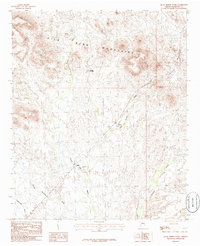 1986 Quail Spring Wash1986 Print · USGSMaricopa County's arid backcountry is captured in the mid-1980s as a landscape of named desert washes and mountain ridges. Researchers can trace historical routes through Dendora and locate early mining activity at the Prospect near Saddle Potholes.
 - 1988 Map of Little Horn Mountains
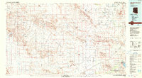 1988 Little Horn Mountains1988 Print · USGSArizona's western desert reaches are captured here in the late eighties, from the protected wilderness to sprawling military training grounds. Researchers can trace the desert hydrology of Hoodoo Wash and the rugged borders of Yuma Proving Ground or Painted Rocks State Park.2 unique versions available
End of results
Showing maps 1-2 of 2
Top cities near Saddle
Frequently asked questions
- What are the different types of historical maps available for Saddle?
- What is the oldest map of Saddle?
- Where can I purchase historical maps of Saddle for my home or office?
- Where can I download high-res historical maps of Saddle?
- Are there historical topographic maps available for Saddle?
- Is there historical aerial imagery available for Saddle?
- Where are historical maps of Saddle sourced from?