1950s Maps of Fort Mohave, Arizona
Explore 5 historic maps of Fort Mohave from the 1950s. These maps offer a rare glimpse into what life looked like during the 1950s — showing old roads, neighborhoods, homes, and landmarks that have changed or disappeared over time.
Whether you're researching your family's past, planning a metal detecting trip, or studying how Fort Mohave's landscape evolved across the 1950s, these high-resolution maps are a powerful tool for exploring the history of this region.
- Focus on a specific era: All maps on this page are from the 1950s, giving you a focused view of this time period.
- See what’s changed: Compare century-old streets, trails, and buildings to today's modern landscape using overlays and satellite layers.
- Research with precision: Use these maps for genealogy, historical research, land use analysis, or educational projects.
- View, download, or print: Maps are fully viewable online in high resolution, and can be downloaded or printed for your own records.
Start exploring Fort Mohave's history through authentic maps from the 1950s. This is your window into the past.
Fort Mohave, AZ maps
(5)- 1950 Map of Davis Dam, 1955 Print
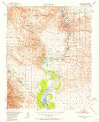 1950 Davis Dam1955 Print · USGSThe Colorado River corridor was undergoing a massive transformation in the early fifties as the newly completed Davis Dam began reshaping the tri-state border. Researchers can trace vanished river landings and frontier outposts such as the Hardyville Site, Mohave City, and the Fort Mohave Ruins.2 unique versions available
 - 1952 Map of Davis Dam
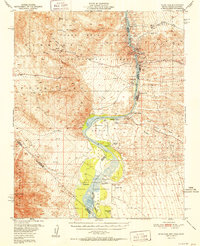 1952 Davis Dam1952 Print · USGSThe Colorado River valley emerges in a period of significant change during the early fifties, as modern infrastructure meets pioneer history. Genealogists and historians can trace family-named locations such as Hardyville Ranch alongside significant landmarks like Fort Mohave (Ruins) and Bullhead City.2 unique versions available
 - 1954 Map of Kingman, 1964 Print
 1954 Kingman1964 Print · USGSThe High Desert borderlands come to life in the mid-fifties, showing the intersection of mining legacies and massive river projects. Researchers can trace old rail stops like Roach Station, mining sites such as Chloride, and river landmarks like Searchlight Ferry.4 unique versions available
 - 1955 Map of Kingman
 1955 Kingman1955 Print · USGSThe Mojave Desert and Colorado River corridor come alive in the mid-fifties, showing a landscape of mining camps and rail junctions. Trace the river to the Searchlight Ferry or locate old desert mining sites like Goldroad and the Great Monster Mine.
 - 1958 Map of Kingman
 1958 Kingman1958 Print · USGSThe tri-state desert borders of Arizona, Nevada, and California are shown in the late fifties as a network of mining camps and river crossings. Genealogists and historians can trace the legacy of remote outposts like Oatman, Chloride, and the Searchlight Ferry along the Colorado River.2 unique versions available
End of results
Showing maps 1-5 of 5
Top cities near Fort Mohave
- Bullhead City historical maps
- Laughlin historical maps
- Needles historical maps
- Mohave Valley historical maps
- Willow Valley historical maps
- Arizona Village historical maps
See more
Frequently asked questions
- What are the different types of historical maps available for Fort Mohave?
- What is the oldest map of Fort Mohave?
- Where can I purchase historical maps of Fort Mohave for my home or office?
- Where can I download high-res historical maps of Fort Mohave?
- Are there historical topographic maps available for Fort Mohave?
- Is there historical aerial imagery available for Fort Mohave?
- Where are historical maps of Fort Mohave sourced from?