1950s Maps of Willow Beach, Arizona
Explore 5 historic maps of Willow Beach from the 1950s. These maps offer a rare glimpse into what life looked like during the 1950s — showing old roads, neighborhoods, homes, and landmarks that have changed or disappeared over time.
Whether you're researching your family's past, planning a metal detecting trip, or studying how Willow Beach's landscape evolved across the 1950s, these high-resolution maps are a powerful tool for exploring the history of this region.
- Focus on a specific era: All maps on this page are from the 1950s, giving you a focused view of this time period.
- See what’s changed: Compare century-old streets, trails, and buildings to today's modern landscape using overlays and satellite layers.
- Research with precision: Use these maps for genealogy, historical research, land use analysis, or educational projects.
- View, download, or print: Maps are fully viewable online in high resolution, and can be downloaded or printed for your own records.
Start exploring Willow Beach's history through authentic maps from the 1950s. This is your window into the past.
Willow Beach, AZ maps
(5)- 1954 Map of Kingman, 1964 Print
 1954 Kingman1964 Print · USGSThe High Desert borderlands come to life in the mid-fifties, showing the intersection of mining legacies and massive river projects. Researchers can trace old rail stops like Roach Station, mining sites such as Chloride, and river landmarks like Searchlight Ferry.4 unique versions available
 - 1955 Map of Kingman
 1955 Kingman1955 Print · USGSThe Mojave Desert and Colorado River corridor come alive in the mid-fifties, showing a landscape of mining camps and rail junctions. Trace the river to the Searchlight Ferry or locate old desert mining sites like Goldroad and the Great Monster Mine.
 - 1958 Map of Kingman
 1958 Kingman1958 Print · USGSThe tri-state desert borders of Arizona, Nevada, and California are shown in the late fifties as a network of mining camps and river crossings. Genealogists and historians can trace the legacy of remote outposts like Oatman, Chloride, and the Searchlight Ferry along the Colorado River.2 unique versions available
 - 1959 Map of Willow Beach, 1960 Print
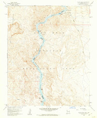 1959 Willow Beach1960 Print · USGSThe Colorado River corridor at the Arizona-Nevada border is shown in detail during the late fifties, highlighting the early development of the Black Canyon National Recreation Area. Local historians can trace the topography of the El Dorado Mountains and locate landmarks like Willow Beach, Copper Basin, and The Caves.3 unique versions available
 - 1959 Map of Black Canyon, 1961 Print
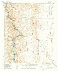 1959 Black Canyon1961 Print · USGSThe Colorado River corridor along the Arizona-Nevada border comes alive in the late fifties, showcasing the early infrastructure of the Lake Mead National Recreation Area. Researchers can trace the river's path through Ringbolt Rapids and locate isolated sites like the Two Bs Mine or the State Fish Hatchery.3 unique versions available
End of results
Showing maps 1-5 of 5
Top cities near Willow Beach
Frequently asked questions
- What are the different types of historical maps available for Willow Beach?
- What is the oldest map of Willow Beach?
- Where can I purchase historical maps of Willow Beach for my home or office?
- Where can I download high-res historical maps of Willow Beach?
- Are there historical topographic maps available for Willow Beach?
- Is there historical aerial imagery available for Willow Beach?
- Where are historical maps of Willow Beach sourced from?