1980s Maps of Willow Valley, Arizona
Explore 2 historic maps of Willow Valley from the 1980s. These maps offer a rare glimpse into what life looked like during the 1980s — showing old roads, neighborhoods, homes, and landmarks that have changed or disappeared over time.
Whether you're researching your family's past, planning a metal detecting trip, or studying how Willow Valley's landscape evolved across the 1980s, these high-resolution maps are a powerful tool for exploring the history of this region.
- Focus on a specific era: All maps on this page are from the 1980s, giving you a focused view of this time period.
- See what’s changed: Compare century-old streets, trails, and buildings to today's modern landscape using overlays and satellite layers.
- Research with precision: Use these maps for genealogy, historical research, land use analysis, or educational projects.
- View, download, or print: Maps are fully viewable online in high resolution, and can be downloaded or printed for your own records.
Start exploring Willow Valley's history through authentic maps from the 1980s. This is your window into the past.
Willow Valley, AZ maps
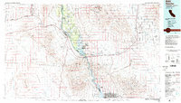
(2)- 1981 Map of Needles, 1987 Print
 1981 Needles1987 Print · USGSThe High Desert and Colorado River valley are seen here in the early 1980s through the unique lens of satellite imagery. Trace the isolated outposts of the AT & SF railroad at Goffs and Essex, or explore the sprawling shores of Lake Havasu.
 - 1985 Map of Needles
 1985 Needles1985 Print · USGSThe Colorado River borderlands in the mid-1980s show a region shaped by major infrastructure and desert transit. Genealogists and historians can trace the path of U S 66 and the Atchison Topeka and Santa Fe through settlements like Needles, Goffs, and Topock.
End of results
Showing maps 1-2 of 2
Top cities near Willow Valley
- Bullhead City historical maps
- Fort Mohave historical maps
- Needles historical maps
- Mohave Valley historical maps
- Golden Shores historical maps
- Arizona Village historical maps
See more
Frequently asked questions
- What are the different types of historical maps available for Willow Valley?
- What is the oldest map of Willow Valley?
- Where can I purchase historical maps of Willow Valley for my home or office?
- Where can I download high-res historical maps of Willow Valley?
- Are there historical topographic maps available for Willow Valley?
- Is there historical aerial imagery available for Willow Valley?
- Where are historical maps of Willow Valley sourced from?