1900s (20th Century) Maps of Baby Rocks, Arizona
Explore 7 historic maps of Baby Rocks from the 1900s (20th Century). These maps offer a rare glimpse into what life looked like during the 1900s — showing old roads, neighborhoods, homes, and landmarks that have changed or disappeared over time.
Whether you're researching your family's past, planning a metal detecting trip, or studying how Baby Rocks's landscape evolved across the 1900s, these high-resolution maps are a powerful tool for exploring the history of this region.
- Focus on a specific era: All maps on this page are from the 1900s, giving you a focused view of this time period.
- See what’s changed: Compare century-old streets, trails, and buildings to today's modern landscape using overlays and satellite layers.
- Research with precision: Use these maps for genealogy, historical research, land use analysis, or educational projects.
- View, download, or print: Maps are fully viewable online in high resolution, and can be downloaded or printed for your own records.
Start exploring Baby Rocks's history through authentic maps from the 1900s. This is your window into the past.
Baby Rocks, AZ maps
(7)- 1952 Map of Agathla Peak 1 SE, 1954 Print
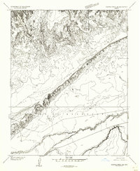 1952 Agathla Peak 1 SE1954 Print · USGSNortheastern Arizona and the high desert of the Navajo Nation are captured here in the early fifties. Local researchers can trace the course of Laguna Creek past Baby Rocks and across the Navajo Co and Apache Co line.
 - 1952 Map of Agathla Peak, 1954 Print
 1952 Agathla Peak1954 Print · USGSThe high desert of the Navajo Nation is captured here in the early fifties, documenting a landscape of ancient ruins and iconic monoliths. Trace historical sites like Echo Cave Ruin and Goulding Well, or locate the towering Agathla Peak and Merrick Butte.3 unique versions available
 - 1956 Map of Marble Canyon, 1964 Print
 1956 Marble Canyon1964 Print · USGSNorthern Arizona and the borderlands of Utah are mapped here in the mid-fifties, showing a landscape defined by traditional trading posts and early uranium mining. Trace old routes between Tuba City and Kayenta, and locate historic sites like Lees Ferry and Inscription House Trading Post.4 unique versions available
 - 1959 Map of Marble Canyon
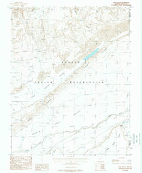
 1959 Marble Canyon1959 Print · USGSNorthern Arizona in the late fifties is a vast landscape of tribal lands and desert plateaus defined by the carving of the Colorado River. Trace family roots and regional history at Tuba City, the Chilchinbito Trading Post, or the ancient Inscription House Ruin.
 - 1961 Map of Marble Canyon
 1961 Marble Canyon1961 Print · USGSThe northern Arizona desert in the early sixties reveals a landscape of tribal lands and canyon crossings. Trace the old river life at Lees Ferry, find the Uranium mill at Tuba City, and locate the iconic Elephant Feet landmarks.
 - 1984 Map of Kayenta
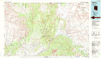 1984 Kayenta1984 Print · USGSThe Navajo Nation in the mid-1980s reveals a landscape of massive sandstone mesas and ancient monuments. Researchers can trace the development of Kayenta and find landmarks like Yellow Water Mine, Goulding Well, and the Navajo National Monument.
 - 1988 Map of Baby Rocks
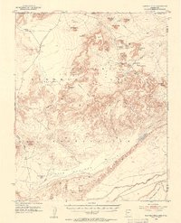
 1988 Baby Rocks1988 Print · USGSThe Navajo Nation's high desert landscape comes alive in the late eighties, documenting the geological transition between two counties. Trace the namesake settlement of Baby Rocks and the dramatic relief of Comb Ridge as it overlooks Laguna Creek and Arch Canyon.
End of results
Showing maps 1-7 of 7
Top cities near Baby Rocks
- Shiprock Agency historical maps
- Kayenta historical maps
- Chinle Agency historical maps
- Dennehotso historical maps
Frequently asked questions
- What are the different types of historical maps available for Baby Rocks?
- What is the oldest map of Baby Rocks?
- Where can I purchase historical maps of Baby Rocks for my home or office?
- Where can I download high-res historical maps of Baby Rocks?
- Are there historical topographic maps available for Baby Rocks?
- Is there historical aerial imagery available for Baby Rocks?
- Where are historical maps of Baby Rocks sourced from?