1900s (20th Century) Maps of Goodwater, Arizona
Explore 8 historic maps of Goodwater from the 1900s (20th Century). These maps offer a rare glimpse into what life looked like during the 1900s — showing old roads, neighborhoods, homes, and landmarks that have changed or disappeared over time.
Whether you're researching your family's past, planning a metal detecting trip, or studying how Goodwater's landscape evolved across the 1900s, these high-resolution maps are a powerful tool for exploring the history of this region.
- Focus on a specific era: All maps on this page are from the 1900s, giving you a focused view of this time period.
- See what’s changed: Compare century-old streets, trails, and buildings to today's modern landscape using overlays and satellite layers.
- Research with precision: Use these maps for genealogy, historical research, land use analysis, or educational projects.
- View, download, or print: Maps are fully viewable online in high resolution, and can be downloaded or printed for your own records.
Start exploring Goodwater's history through authentic maps from the 1900s. This is your window into the past.
Goodwater, AZ maps
(8)- 1912 Map of Petrified Forest
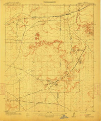 1912 Petrified Forest1912 Print · USGSArizona's high desert was a remote frontier of fossils and rail travel just after the turn of the century. Genealogists and historians can trace early outposts like Adamana and Ortegas Ranch or locate archeological sites such as Indian Ruins and The Pictographs.2 unique versions available
 - 1954 Map of Saint Johns, 1968 Print
 1954 Saint Johns1968 Print · USGSThe high plateau of the Arizona-New Mexico border is captured here in the mid-1950s, showing the intersection of tribal lands and national forests. Researchers can trace the cattle country and mountain outposts from Saint Johns to Pie Town and McNary.3 unique versions available
 - 1955 Map of Petrified Forest, 1956 Print
 1955 Petrified Forest1956 Print · USGSThe high desert of Navajo and Apache counties comes into focus in the mid-1950s, centered on the protected lands of the Petrified Forest National Monument. Researchers can trace the early path of U. S. 66 and locate pioneer outposts such as Ortegas Ranch and the station at Adamana.
 - 1957 Map of Saint Johns
 1957 Saint Johns1957 Print · USGSThe Arizona-New Mexico borderlands are captured here in the mid-fifties, showing the high-country settlements and federal lands before modern development. Genealogists and historians can trace old homesteads and landmarks like the Red Hill Post Office, Lyman Reservoir, and the mountain communities of Eagar and Springerville.
 - 1958 Map of Saint Johns
 1958 Saint Johns1958 Print · USGSEastern Arizona and western New Mexico appear here in the late fifties, showcasing the high plateau and forest landscapes along the Continental Divide. Researchers can trace early ranching routes and water systems like Lyman Reservoir or locate remote settlements such as Fence Lake and Atarque.2 unique versions available
 - 1962 Map of Saint Johns
 1962 Saint Johns1962 Print · USGSEastern Arizona and the New Mexico borderlands come alive in the early sixties, showing a landscape of high-plateau ranching and early national monuments. Trace the path of the Atchison Topeka and Santa Fe or locate old water sources like Salado Springs and Lyman Reservoir.
 - 1981 Map of Saint Johns, 1996 Print
 1981 Saint Johns1996 Print · USGSNortheastern Arizona's high plateau comes into focus in the early 1980s, centered on the settlement of St Johns. Researchers can trace the Atchison Topeka and Santa Fe railroad through Adamana and locate landmarks like Lyman Lake and Zion Reservoir.
 - 1982 Map of Carrizo Butte, 1983 Print
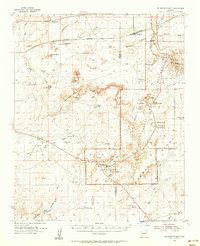
 1982 Carrizo Butte1983 Print · USGSThe high desert of Navajo County comes into focus in the early 1980s, centered on the vital rail corridor and rugged geology of the Puerco River valley. Researchers can trace ranching history and early rail alignments through Ortegas Ranch, Goodwater, and the Ramsey Slide.
End of results
Showing maps 1-8 of 8
Top cities near Goodwater
Frequently asked questions
- What are the different types of historical maps available for Goodwater?
- What is the oldest map of Goodwater?
- Where can I purchase historical maps of Goodwater for my home or office?
- Where can I download high-res historical maps of Goodwater?
- Are there historical topographic maps available for Goodwater?
- Is there historical aerial imagery available for Goodwater?
- Where are historical maps of Goodwater sourced from?