1990s Maps of Chico Shunie, Arizona
Explore 2 historic maps of Chico Shunie from the 1990s. These maps offer a rare glimpse into what life looked like during the 1990s — showing old roads, neighborhoods, homes, and landmarks that have changed or disappeared over time.
Whether you're researching your family's past, planning a metal detecting trip, or studying how Chico Shunie's landscape evolved across the 1990s, these high-resolution maps are a powerful tool for exploring the history of this region.
- Focus on a specific era: All maps on this page are from the 1990s, giving you a focused view of this time period.
- See what’s changed: Compare century-old streets, trails, and buildings to today's modern landscape using overlays and satellite layers.
- Research with precision: Use these maps for genealogy, historical research, land use analysis, or educational projects.
- View, download, or print: Maps are fully viewable online in high resolution, and can be downloaded or printed for your own records.
Start exploring Chico Shunie's history through authentic maps from the 1990s. This is your window into the past.
Chico Shunie, AZ maps
(2)- 1990 Map of Chico Shunie, 1991 Print
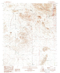 1990 Chico Shunie1991 Print · USGSThe Pima County desert landscape is documented here during the late twentieth century, showing a mix of protected wildlife areas and military range. Researchers can locate remote desert landmarks such as the San Antonio Mine, the John the Baptist (Site), and The Adobe.
 - 1996 Map of Chico Shunie, 2000 Print
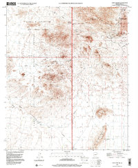 1996 Chico Shunie2000 Print · USGSThe Pima County desert reveals its mining and military history in the late 1990s. Trace old claims near Cardigan Peak, find the remote John the Baptist (Site), and locate water sources like Valentine Well and Little Tule Well.
End of results
Showing maps 1-2 of 2
Top cities near Chico Shunie
Frequently asked questions
- What are the different types of historical maps available for Chico Shunie?
- What is the oldest map of Chico Shunie?
- Where can I purchase historical maps of Chico Shunie for my home or office?
- Where can I download high-res historical maps of Chico Shunie?
- Are there historical topographic maps available for Chico Shunie?
- Is there historical aerial imagery available for Chico Shunie?
- Where are historical maps of Chico Shunie sourced from?