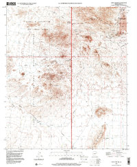
1996 Map of Chico Shunie
USGS Topo · Published 2000About this map
Arid desert basins and prominent peaks dominate this corner of Pima County, where the Cabeza Prieta National Wildlife Refuge and the Barry M Goldwater Air Force Range meet. The landscape is defined by the sharp elevations of the Little Ajo Mountains and the Chico Shunie Hills, which are marked by numerous mining features such as Prospects, Mine Shafts, and an Adit. These small-scale excavations suggest a history of prospecting throughout the rocky outcrops of Cardigan Peak and Pinnacle Peak.
Find a feature on this map
35 named features on this map. Tap any name to fly to it.
Don’t see what you’re looking for? This feature index may not catch every label — zoom into the map to look around manually.
Map Details
Editions of this 1996 Chico Shunie Map
This is the sole edition of this map. No revisions or reprints were ever made.
Other maps of this area

1932 · Ajo
USGS Topo · 1:62,500

1934 · Ajo
USGS Topo · 1:62,500

1953 · Ajo
USGS Topo · 1:250,000

1957 · Ajo
USGS Topo · 1:250,000

1958 · Ajo
USGS Topo · 1:250,000

1962 · Ajo
USGS Topo · 1:250,000

1963 · Ajo
USGS Topo · 1:250,000

1963 · Ajo
USGS Topo · 1:62,500

1963 · Kino Peak
USGS Topo · 1:62,500

1964 · Growler Peak
USGS Topo · 1:62,500