
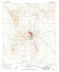
1963 Map of Ajo
USGS Topo · Published 1964About this map
Industrial expansion and desert settlements define this landscape, dominated by the massive New Cornelia Mine and its accompanying infrastructure. The town of Ajo serves as the central hub, surrounded by distinct residential areas such as Mexican Town, Gibson, and Rowood. The intricate network of the Tucson Cornelia and Gila Bend Railroad facilitates the movement of ore and supplies, connecting the mine's Concentrator Hill to the broader region.
Find a feature on this map
71 named features on this map. Tap any name to fly to it.
Don’t see what you’re looking for? This feature index may not catch every label — zoom into the map to look around manually.
Map Details
Editions of this 1963 Ajo Map
2 editions found
Other maps of this area

1932 · Ajo
USGS Topo · 1:62,500

1934 · Ajo
USGS Topo · 1:62,500

1953 · Ajo
USGS Topo · 1:250,000

1957 · Ajo
USGS Topo · 1:250,000

1958 · Ajo
USGS Topo · 1:250,000

1958 · Midway
USGS Topo · 1:62,500

1958 · Hat Mountain
USGS Topo · 1:62,500

1962 · Ajo
USGS Topo · 1:250,000

1963 · Ajo
USGS Topo · 1:250,000

1963 · Sikort Chuapo Mts
USGS Topo · 1:62,500