
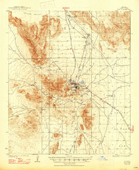
1934 Map of Ajo
USGS Topo · Published 1934About this map
The New Cornelia Mines dominate the industrial landscape of Pima County in the early 1930s, centering on the settlement of Ajo and its surrounding worker communities. This survey reveals a distinct social geography, with Mexican Town, Gibson, and Clarkstown Rowood P O clustered near the primary mining operations and Concentrator Hill. Beyond the industrial core, the map captures a network of essential water sources in the desert, including Bates Well, Teco Shanie Well, and Thoms Well, which supported isolated outposts like Sneed Ranch. Transportation through the Valley of the Ajo relied on the Gila Bend and Cornella Road and the Tucson Highway. Notable landmarks of the era include the Ajo Golf Club and Ajo Landing Field, illustrating the town's development alongside its copper-driven economy.
Find a feature on this map
35 named features on this map. Tap any name to fly to it.
Don’t see what you’re looking for? This feature index may not catch every label — zoom into the map to look around manually.
Map Details
Editions of this 1934 Ajo Map
2 editions found
Other maps of this area

1932 · Ajo
USGS Topo · 1:62,500

1953 · Ajo
USGS Topo · 1:250,000

1957 · Ajo
USGS Topo · 1:250,000

1958 · Ajo
USGS Topo · 1:250,000

1958 · Midway
USGS Topo · 1:62,500

1958 · Hat Mountain
USGS Topo · 1:62,500

1962 · Ajo
USGS Topo · 1:250,000

1963 · Ajo
USGS Topo · 1:250,000

1963 · Ajo
USGS Topo · 1:62,500

1963 · Sikort Chuapo Mts
USGS Topo · 1:62,500