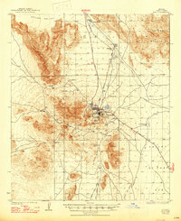
1934 Map of Ajo
USGS Topo · Published 1947About this map
The New Cornelia Mines dominate this desert landscape, revealing the industrial scale of copper mining in Pima County during the early 1930s. The map captures the distinct social geography of the era, showing Ajo alongside Mexican Town, Gibson, and the community of Clarkstown Rowood PO. This cluster of settlements, supported by the Tucson Cornelia and Gila Bend RR, illustrates a company town and its peripheral neighborhoods at their height. Beyond the industrial center, the topography transitions into the Little Ajo Mountains and the volcanic peaks of Ajo Peak and North Ajo Pk. To the north and west, the vast Childs Valley is marked by essential water sources like Batamote Well and Chico Shunie Well, alongside the remote Sneed Ranch and Childs Ranch, highlighting the isolation and resilience of early ranching operations in the Sonoran Desert.
Find a feature on this map
40 named features on this map. Tap any name to fly to it.
Don’t see what you’re looking for? This feature index may not catch every label — zoom into the map to look around manually.
Map Details
Editions of this 1934 Ajo Map
2 editions found
Other maps of this area

1932 · Ajo
USGS Topo · 1:62,500

1934 · Ajo
USGS Topo · 1:62,500

1953 · Ajo
USGS Topo · 1:250,000

1957 · Ajo
USGS Topo · 1:250,000

1958 · Ajo
USGS Topo · 1:250,000

1958 · Midway
USGS Topo · 1:62,500

1958 · Hat Mountain
USGS Topo · 1:62,500

1962 · Ajo
USGS Topo · 1:250,000

1963 · Ajo
USGS Topo · 1:250,000

1963 · Ajo
USGS Topo · 1:62,500