1990s Maps of Hotason Vo, Hickiwan
Explore 2 historic maps of Hotason Vo from the 1990s. These maps offer a rare glimpse into what life looked like during the 1990s — showing old roads, neighborhoods, homes, and landmarks that have changed or disappeared over time.
Whether you're researching your family's past, planning a metal detecting trip, or studying how Hotason Vo's landscape evolved across the 1990s, these high-resolution maps are a powerful tool for exploring the history of this region.
- Focus on a specific era: All maps on this page are from the 1990s, giving you a focused view of this time period.
- See what’s changed: Compare century-old streets, trails, and buildings to today's modern landscape using overlays and satellite layers.
- Research with precision: Use these maps for genealogy, historical research, land use analysis, or educational projects.
- View, download, or print: Maps are fully viewable online in high resolution, and can be downloaded or printed for your own records.
Start exploring Hotason Vo's history through authentic maps from the 1990s. This is your window into the past.
Hotason Vo, Hickiwan maps
(2)- 1990 Map of Hotason Vo
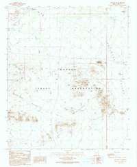 1990 Hotason Vo1990 Print · USGSIn the Sonoran Desert of the 1990s, this area of the Papago Indian Reservation centers on the local settlements of Hotason Vo and Chagit Vo. Researchers can trace old mining efforts at Little Chief Mine or locate the small cemetery and Check Dams that mark the local landscape.
 - 1996 Map of Hotason Vo, 2000 Print
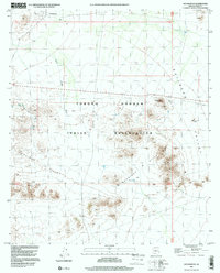 1996 Hotason Vo2000 Print · USGSWithin the Tohono O'odham Indian Reservation during the late nineties, this map documents a traditional desert landscape centered on community and resource extraction. Trace old mining operations at Little Chief Mine and find the small settlements of Hotason Vo and Chagit Vo.
End of results
Showing maps 1-2 of 2
Frequently asked questions
- What are the different types of historical maps available for Hotason Vo?
- What is the oldest map of Hotason Vo?
- Where can I purchase historical maps of Hotason Vo for my home or office?
- Where can I download high-res historical maps of Hotason Vo?
- Are there historical topographic maps available for Hotason Vo?
- Is there historical aerial imagery available for Hotason Vo?
- Where are historical maps of Hotason Vo sourced from?