1990s Maps of Stoa Pitk, Hickiwan
Explore 2 historic maps of Stoa Pitk from the 1990s. These maps offer a rare glimpse into what life looked like during the 1990s — showing old roads, neighborhoods, homes, and landmarks that have changed or disappeared over time.
Whether you're researching your family's past, planning a metal detecting trip, or studying how Stoa Pitk's landscape evolved across the 1990s, these high-resolution maps are a powerful tool for exploring the history of this region.
- Focus on a specific era: All maps on this page are from the 1990s, giving you a focused view of this time period.
- See what’s changed: Compare century-old streets, trails, and buildings to today's modern landscape using overlays and satellite layers.
- Research with precision: Use these maps for genealogy, historical research, land use analysis, or educational projects.
- View, download, or print: Maps are fully viewable online in high resolution, and can be downloaded or printed for your own records.
Start exploring Stoa Pitk's history through authentic maps from the 1990s. This is your window into the past.
Stoa Pitk, Hickiwan maps
(2)- 1990 Map of Coffeepot Mountain, 1991 Print
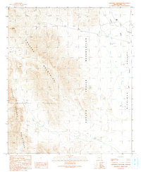 1990 Coffeepot Mountain1991 Print · USGSThe Papago Indian Reservation is captured here in the early 1990s as a desert landscape shaped by dramatic ranges and seasonal washes. Researchers can locate the settlement of Stoa Pitk, find the site of Graves, and trace water features like Hickiwan Wash.
 - 1996 Map of Coffeepot Mountain, 2001 Print
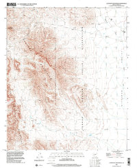 1996 Coffeepot Mountain2001 Print · USGSThe high desert of Pima County comes to life in the late nineties, showcasing the intersection of traditional tribal lands and modern infrastructure. Genealogists and historians can locate Stoa Pitk, trace the Hickiwan Wash, and find local burials at the Cemetery or Graves.
End of results
Showing maps 1-2 of 2
Frequently asked questions
- What are the different types of historical maps available for Stoa Pitk?
- What is the oldest map of Stoa Pitk?
- Where can I purchase historical maps of Stoa Pitk for my home or office?
- Where can I download high-res historical maps of Stoa Pitk?
- Are there historical topographic maps available for Stoa Pitk?
- Is there historical aerial imagery available for Stoa Pitk?
- Where are historical maps of Stoa Pitk sourced from?