1980s Maps of Stoa Pitk, Hickiwan
Explore 2 historic maps of Stoa Pitk from the 1980s. These maps offer a rare glimpse into what life looked like during the 1980s — showing old roads, neighborhoods, homes, and landmarks that have changed or disappeared over time.
Whether you're researching your family's past, planning a metal detecting trip, or studying how Stoa Pitk's landscape evolved across the 1980s, these high-resolution maps are a powerful tool for exploring the history of this region.
- Focus on a specific era: All maps on this page are from the 1980s, giving you a focused view of this time period.
- See what’s changed: Compare century-old streets, trails, and buildings to today's modern landscape using overlays and satellite layers.
- Research with precision: Use these maps for genealogy, historical research, land use analysis, or educational projects.
- View, download, or print: Maps are fully viewable online in high resolution, and can be downloaded or printed for your own records.
Start exploring Stoa Pitk's history through authentic maps from the 1980s. This is your window into the past.
Stoa Pitk, Hickiwan maps
(2)- 1980 Map of Ajo, 1996 Print
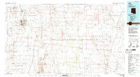 1980 Ajo1996 Print · USGSIn the Sonoran Desert during the early 1980s, mining operations and tribal lands shaped the landscape of Pima County. Researchers can trace the development of Ajo and Why, locate desert outposts like San Simon Well, and identify old workings at the Bluebird Mine.
 - 1982 Map of Ajo
 1982 Ajo1982 Print · USGSThe Arizona-Sonora borderlands come into focus in the early eighties, showcasing a landscape of desert mining towns and expansive tribal lands. Trace the Southern Pacific rail line through Gila Bend or explore the remote settlements of Ajo and Lukeville.
End of results
Showing maps 1-2 of 2
Frequently asked questions
- What are the different types of historical maps available for Stoa Pitk?
- What is the oldest map of Stoa Pitk?
- Where can I purchase historical maps of Stoa Pitk for my home or office?
- Where can I download high-res historical maps of Stoa Pitk?
- Are there historical topographic maps available for Stoa Pitk?
- Is there historical aerial imagery available for Stoa Pitk?
- Where are historical maps of Stoa Pitk sourced from?