1990s Maps of Ventana, Hickiwan
Explore 2 historic maps of Ventana from the 1990s. These maps offer a rare glimpse into what life looked like during the 1990s — showing old roads, neighborhoods, homes, and landmarks that have changed or disappeared over time.
Whether you're researching your family's past, planning a metal detecting trip, or studying how Ventana's landscape evolved across the 1990s, these high-resolution maps are a powerful tool for exploring the history of this region.
- Focus on a specific era: All maps on this page are from the 1990s, giving you a focused view of this time period.
- See what’s changed: Compare century-old streets, trails, and buildings to today's modern landscape using overlays and satellite layers.
- Research with precision: Use these maps for genealogy, historical research, land use analysis, or educational projects.
- View, download, or print: Maps are fully viewable online in high resolution, and can be downloaded or printed for your own records.
Start exploring Ventana's history through authentic maps from the 1990s. This is your window into the past.
Ventana, Hickiwan maps
(2)- 1990 Map of Ventana
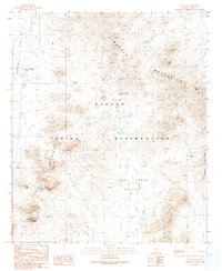 1990 Ventana1990 Print · USGSThe Papago Indian Reservation in southern Arizona is depicted here in the late twentieth century, centered on the settlement of Ventana. Researchers can locate mining sites like the Isabella Mine and distinctive cultural landmarks such as Ventana Cave and a local Cemetery.
 - 1996 Map of Ventana, 2003 Print
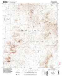 1996 Ventana2003 Print · USGSThe Tohono O'odham interior of Pima County is captured here in the mid-1990s, showcasing a landscape of desert mining and isolated settlements. Researchers can locate the Isabella Mine, trace the Anegam Wash, and identify the Cem near Ventana.
End of results
Showing maps 1-2 of 2
Top cities near Ventana
Frequently asked questions
- What are the different types of historical maps available for Ventana?
- What is the oldest map of Ventana?
- Where can I purchase historical maps of Ventana for my home or office?
- Where can I download high-res historical maps of Ventana?
- Are there historical topographic maps available for Ventana?
- Is there historical aerial imagery available for Ventana?
- Where are historical maps of Ventana sourced from?