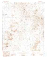
1990 Map of Ventana
USGS Topo · Published 1990About this map
Ventana is situated at the western base of the Cimarron Mountains within the Papago Indian Reservation. This arid Sonoran landscape is defined by the convergence of the Kaka Valley and the Chui Tontk Valley, where ephemeral water sources like Salt Well and Muik Vaya indicate the vital importance of groundwater for survival in this environment. The map details localized industrial activity and archaeological significance, featuring several mine shafts, the Isabella Mine, and the New Ore Mine tucked into the mountain slopes.
Find a feature on this map
21 named features on this map. Tap any name to fly to it.
Don’t see what you’re looking for? This feature index may not catch every label — zoom into the map to look around manually.
Map Details
Editions of this 1990 Ventana Map
This is the sole edition of this map. No revisions or reprints were ever made.
Other maps of this area

1941 · Vekol Mountains
USGS Topo · 1:62,500

1942 · Vekol Mountains
USGS Topo · 1:62,500

1953 · Ajo
USGS Topo · 1:250,000

1957 · Ajo
USGS Topo · 1:250,000

1958 · Ajo
USGS Topo · 1:250,000

1958 · Kaka
USGS Topo · 1:62,500

1962 · Ajo
USGS Topo · 1:250,000

1963 · Ajo
USGS Topo · 1:250,000

1963 · Gu Achi
USGS Topo · 1:62,500

1963 · Cimarron Peak
USGS Topo · 1:62,500