
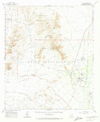
1963 Map of Gu Achi
USGS Topo · Published 1964About this map
Gu Achi (Santa Rosa) and its surrounding desert settlements are central to this 1963 survey of the Papago Indian Reservation. The map documents a landscape where traditional Tohono O'odham villages like Anegam, Ali Oidak, and Akchin are connected by a network of jeep trails and desert washes. The economy of the era is visible through the Santa Rosa Trading Post and a collection of scattered mining operations tucked into the heights, including the Montezona Mine and Blackjack Mine near Montazona Pass.
Find a feature on this map
48 named features on this map. Tap any name to fly to it.
Don’t see what you’re looking for? This feature index may not catch every label — zoom into the map to look around manually.
Map Details
Editions of this 1963 Gu Achi Map
2 editions found
Other maps of this area

1934 · Silver Bell
USGS Topo · 1:125,000

1937 · Comobabi
USGS Topo · 1:48,000

1941 · Vekol Mountains
USGS Topo · 1:62,500

1942 · Silver Reef Mountains
USGS Topo · 1:62,500

1942 · Vekol Mountains
USGS Topo · 1:62,500

1942 · Comobabi
USGS Topo · 1:62,500

1953 · Ajo
USGS Topo · 1:250,000

1956 · Tucson
USGS Topo · 1:250,000

1957 · Ajo
USGS Topo · 1:250,000

1958 · Ajo
USGS Topo · 1:250,000
Featured Places
- Anegam, Sif Oidak District
- Ak Chin, Gu Achi District
- San Luis, Gu Achi District
- Hickiwan, AZ
- Sif Oidak District, AZ