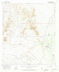
1963 Map of Gu Achi
USGS Topo · Published 1973About this map
The Papago Indian Reservation dominates this desert landscape, characterized by isolated mountain ranges and broad alluvial valleys mapped in the early 1960s. The settlement of Gu Achi (Santa Rosa) serves as a primary focal point, anchored by the Santa Rosa Trading Post and a nearby sewage disposal site. The cultural landscape is punctuated by unique spiritual and communal markers, such as the Childrens Shrine and several cemeteries near Anegam and San Luis.
Find a feature on this map
52 named features on this map. Tap any name to fly to it.
Don’t see what you’re looking for? This feature index may not catch every label — zoom into the map to look around manually.
Map Details
Editions of this 1963 Gu Achi Map
2 editions found

Other maps of this area

1934 · Silver Bell
USGS Topo · 1:125,000

1937 · Comobabi
USGS Topo · 1:48,000

1941 · Vekol Mountains
USGS Topo · 1:62,500

1942 · Silver Reef Mountains
USGS Topo · 1:62,500

1942 · Vekol Mountains
USGS Topo · 1:62,500

1942 · Comobabi
USGS Topo · 1:62,500

1953 · Ajo
USGS Topo · 1:250,000

1956 · Tucson
USGS Topo · 1:250,000

1957 · Ajo
USGS Topo · 1:250,000

1958 · Ajo
USGS Topo · 1:250,000
Featured Places
- Anegam, Sif Oidak District
- Ak Chin, Gu Achi District
- San Luis, Gu Achi District
- Hickiwan, AZ
- Sif Oidak District, AZ